| Akko |
| Conserving Two of the Ottoman Aqueduct Water Towers in ʽAkko |
| Implemented by: |
Landscape Arch. Ido Rosental
Arch. Yaara Shaltiel
Vadim Zaytlin
|
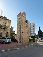
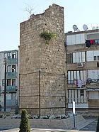
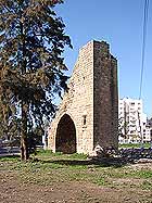
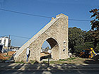
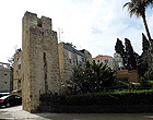
A person wandering the streets of modern Acre, which developed outside the Old City walls, is likely to encounter several strange looking kurkar towers standing on the sides of the streets and rising to a height of 12-10 meters above the pavement. These towers, which to this day are mistakenly referred to as siphons, are a remnant of the system that supplied water to Old ʽAkko and was constructed in 1815 at the behest of the governor Suleiman Pasha. There are those that say the towers are older, and are part of the system built in the early eighteenth century, during the reign of the infamous ruler Ahmad Al-Jazzar Pasha.
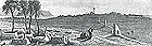
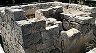
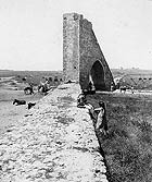
These towers are today dwarfed alongside the adjacent buildings, vegetation and street lights (Figs. 1–3); but in previous centuries these structures were such exceptional phenomena in the landscape (Fig. 4) that they were each given a name, even though they were merely technical installations.
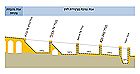
The northern and better known part of the aqueduct is mostly built as an open water channel borne atop a wall or arches that gently slope towards ʽAkko; however, the water in the aqueduct near the city entered a system of sealed pipes buried in a low wall that was literally constructed on the ground. According to the principle of communicating vessels, the water from the open channel first flowed into the pipes along a diagonal chute and was then conveyed under high pressure into low segments called a 'gichon'. Since it was not possible to establish checkpoints along the low 'gichon' due to the loss of pressure so essential to the conveyance of water, towers were constructed along the pipe at intervals of c. 0.5 km thus dividing it into shorter segments that were more easily maintained, as is also done in modern water systems. Because of their height, few people know that the water that rose to the top of the towers as a result of pressure exited one side of a pool open to the sky located at the top of each tower (Fig. 5) and drained to the other side where it continued to flow down towards the city (Fig. 6). In this way, the tower released the high pressure that was in the pipes. The towers functioned as checkpoints along the pipe and also enabled the flow of water for local needs, such as troughs for people and animals.
Over the years, the shifting ground on which the aqueduct was built caused collapses, leaks and ruptured pipes. The rainwater that gradually seeped into the aqueduct caused the lime used in bonding the stones to crumble and the vegetation that sprouted up between the stones displaced them with its roots. The aqueduct was cleaned and maintained annually during the years it was operated, and in 1873 an extensive project was even carried out in order to replace the dilapidated terra cotta pipes with a pipe made of fine quality stone. Maintenance of the aqueduct was suspended when it ceased to be used in the early 1950s. Large parts of it were completely wiped out, and the condition of its remaining elements deteriorated.
In 2013 conservation measures were implemented in order to remove any hazards in two of the towers: Bab Akka tower on David Noy Street and El-A‘uji tower on Arye Dushnitski Street. A section of about one hundred meters of the low aqueduct (gihon) that survived between the El-Aʽuji tower and the El-Baja chute in the Manof Youth Village was treated. Conservation plans were prepared for the El-Imam tower located on Ha-Arbaʽa Street; however, they have yet to be implemented.
Work was begun on the El-Aʽuji tower and the aqueduct nearby (Fig. 7). The gaps between the stones were refilled, weathered stones were replaced and the old plaster that covered the open pool at the top of the tower was stabilized. Above the pointed vault in the tower – a vault that spanned the old road to Tyre – large cavities discovered in the core of the tower were refilled using special pumps and a technique known as grouting.
The ravages of time were clearly apparent in the section of the aqueduct next to the tower. Numerous stones had fallen from the aqueduct and it was covered with vegetation and even trees with thick trunks. With the help of students from the International Center for Conservation in ʽAkko, the Western Galilee College and a number of volunteers from the surrounding area the vegetation was cleared and eradicated using herbicides. The stones in the aqueduct were reinforced and those that were missing were replaced.
The widening of Arye Dushnitski Street near the tower unfortunately necessitated damaging a section of the aqueduct and dismantling an old trough which in the past was filled with water conveyed to it from the top of the tower (Fig. 8).
The stones in the Bab Akka tower were also stabilized, the joints between the stones were pointed up with new mortar and the plaster on the upper pool was stabilized (Fig. 9). As is the case with El-Aʽuji tower, the original opening was breached again in the side of the tower which led to a vertical shaft that was used as a “ladder” in order to maintain the top of the tower. Metal grates were installed at both ends of the shaft in order to prevent the entry of birds which have nested there since the aqueduct ceased to be used.
Keystone-Mast Collection, UCR / California Museum of Photography, University of California at Riverside.
------------------------------
August 2015
To view the figures, click on the figure caption
|