| Nahal ‘Amud |
| The Flour Mills |
| Stabilizing project |
| Orderer | Nature and Parks Authority |
| Duration | May–November 2013 |
| Implemented by: |
Arch. Amir Freundlich
Eng. Yaacov Schefer
John Peterson
|
In May–November 2013 steps were taken to stabilize the mill remains in Nahal ‘Amud with funding provided by the Nature and Parks Authority and the Milestones Project (heritage infrastructures) in the Prime Minister’s office. The project team consisted of Amir Freundlich (planning architect), Ing. Yaacov Schaffer (engineering consultancy) and Johnny Peterson (conservator and in charge of implementation).
. . . . . . . . . . . . . . . . . . . .
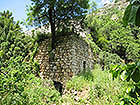
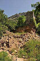
In the years that have gone by since the mills ceased to operate the vegetation in the stream has covered the remains of the buildings and installations and has even taken root in the wall cores of the flour mills. During a storm that occurred in February 2012 an almond tree was uprooted that was growing in the core of a wall of a flour mill thus causing the collapse of the mill onto the visitor’s path in the nature reserve (Figs. 1, 2). This event prompted the decision makers to press forward with the conservation work in order to stabilize the built heritage remains along the course of the stream, to save them from the destructive processes active there and eradicate any risks that might thereby await visitors to the nature reserve.
In a survey that was conducted along a 2.5 kilometer section of the stream in 2004–2006 eighteen flour mills, ten bridges and five diverting dams were identified.
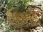
The flour mills in the upper portion of Nahal ‘Amud were constructed in the Crusader period and most of the remains visible today are from the Ottoman period. The line of mills preserves a stretch of ancient installations, probably wool fulling mills, which reached its peak activity in the sixteenth century CE, at the time of the golden age of Safed. Several of the mills operated until the 1950’s.
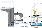
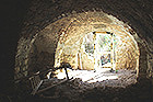
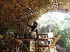
The penstock mills (Fig. 3) were built of indigenous materials and in accordance with the topographic conditions. The energy of the water falling in the penstock from a height of 6.0–9.5 meters was utilized to drive a paddlewheel installed inside an arched cavity at its base. The space where millstones were located was built above the paddle wheel. In most of the mills, close to where the milling was done, arched cavities were built that were used for storage and was where the millers resided. The average area of a mill is about 50 square meters.
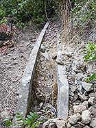
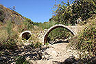
The close density of the installations, which is unknown in our region, characterizes the cultural landscape of Nahal ‘Amud. From that standpoint, it can be viewed as a unique phenomenon. Remains of terraces, flour mills (Fig. 4), sluices (Fig. 5), diverting dams (Fig. 6) and bridges (Fig. 7) are evidence in the landscape of traditional crafts that employed ancient technologies which ceased to be used with the development of industry in the Galilee in the twentieth century. The line of mills is of historic value in that it is evidence of the way of life and traditional crafts in the Galilee in the aforementioned periods.
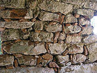
The foliage in the stream played a role in the deterioration of the building remains (Fig. 8). However, the nature and landscape values in the reserve necessitated the use of discretion and sensitivity when it came to pruning or felling vegetation. The inspectors of the nature reserve, under the direction of Lazar Bergman, accompanied the conservation measures and were full partners in the decision making process in this regard.
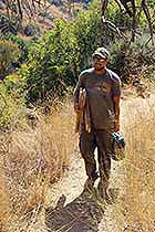
The mills, scattered along the river channel at an average distance of c. 150 meters, are not accessible by vehicle and lack an electrical infrastructure. Under such conditions the work was all done manually, using traditional building methods. The conservators lowered the equipment required for the work by hand (Fig. 9), the mortar was mostly composed of indigenous soil reinforced with hydraulic lime and the water needed for the mixture was pumped from the stream.
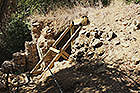
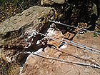
Most of the work was done in six mills located along the stream which were in danger of collapse (according to the survey’s numbering: M11, M12, M13, M16, M20, M21). The conservation measures included removing vegetation from the built components and treating them with an herbicide, installing wooden and stone supports (Fig. 10), installing tensioners (Fig. 11), pointing up joints with mortar (Fig. 12), stabilizing the exposed wall cores, completing stonework in walls and stabilizing walls by means of stones and stone wedges (klinim) (Fig.13).
The uniqueness of the project lies in the minimal intervention that was done solely for the purpose of stabilization, and almost without any development considerations – i.e. interpretation and display, all of which was accomplished under difficult logistical conditions that included the problem of difficult accessibility and a lack of available infrastructures (electricity, transport and materials).
Yael Fuhrmann-Naaman, Amir Freundlich
-------------------------
October 2013
-------------------------
To view the figures, click on the figure caption
|
|