| Galilee Synagogues |
| Saving the Synagogues in the Galilee |
| Conservation from a Regional Perspective |
| Implemented by: |
Yael Alef
Amit Rosenblum
|
The ‘Saving the Synagogues in the Galilee’ project was inaugurated in 2013. For the first time the rescue project made it possible for the Israel Antiquities Authority Conservation Department to initiate a regional conservation program that takes into account the full range of professional considerations relating to heritage conservation. We had to set the framework for the project that included answering such questions as: How many ancient synagogues were exposed in the Galilee? What is their condition? Who is responsible for the sites? What conservation measures are required? For the first time we were asked to compile an inventory of sites for conservation as a basis for formulating a plan of action for the project and establish a special conservation team for carrying out the rescue work at the sites.
For more than a century archaeologists have been engaged in the excavation of ancient synagogues in Israel, and in recent years we have witnessed a resurgence in their research. The Galilee synagogues are included in Israel’s tentative list for inscription on the UNESCO World Heritage list; however, no complete survey of their physical condition has been conducted so far and no conservation program from a comprehensive regional perspective was prepared for them.
The Israel Antiquities Authority database contains archaeological information about the ancient synagogues but there is no data regarding the state of preservation of the remains. There are however more detailed descriptions in the excavation reports but these do not reflect the level of preservation at the sites and the conservation needs today. For instance, in a picture of the northern synagogue at Bar’am taken by the Palestine Exploration Fund’s Survey of Western Palestine, numerous items are visible, as well as impressive doorjambs and a lintel that are standing in situ (Fig. 1). The lintel was moved to the Louvre Museum, other items were plundered and several wall foundations are all that remain in the field today (Fig. 2). At other sites, such as the synagogues at Hamat Gader or Tel Iztabba, the mosaics were removed for display in museums and the rest of the building remains stand abandoned and exposed to the ravages of nature and man (Fig. 3). Like them, there are neglected synagogues in unstable conditions that were also found at ‘Ein Nashut, Dabia and Deir Aziz in the Golan, at Gush Halav, Meron, in Wadi Hammam and at Marot.
The main obstacle to conserving the sites stems from lack of awareness about the cultural values of the synagogues, and sometimes even an awareness of the very existence of the sites. Moreover, the authorities’ lack of information regarding the conservation needs and the development potential of the sites has also resulted in their neglect.
The goal of the project therefore is to put the ancient Galilean synagogues “on the map” in several regards: conserving the remains and strengthening their presence in the landscape, making the information accessible to the public and raising the community’s awareness about the historical heritage in its surroundings. The premise of the rescue project is that the measures will focus on protection, stabilization and conservation and on intervention such as monitoring, maintenance, covering, and “first-aid”, while the development of sites that will be opened to the public will be advanced in other ways.
The Project’s Components
Database
In the first stage we set about building an information infrastructure for the project. For the first time, an inventory (database) for the conservation of archaeological sites was created in cooperation with the IAA Information Technologies Department, on the basis of ArcGIS Desktop and ArcGIS Online for the ESRI geographic information system. This system incorporates an application for mapping (GPS) data from the field and their collection, data access from desktop or mobile devices, spatial analysis and sharing. The system’s properties were tailored in accordance with the information required for the conservation and maintenance of the sites and include: data for identifying the site, information for planning purposes, data on the state of preservation and risks and a cultural assessment of the site. The information was gathered from a conservation survey conducted in the field and from literature, and is combined with the information from the various layers of database in the Israel Antiquities Authority and Geographical Information Forum of the Israel Mapping Center.
This knowledge is the basis for making decisions regarding the manner of intervention at each and every site based on an evaluation of all aspects. It enables the integration of synagogues in determining the different uses of the land at all levels of planning. In addition, the inventory makes it possible to identify sites that are at risk and monitor them. This, together with identifying development potential and setting priorities for the conservation of sites and their development in national and local plans of action. This inventory is a national pilot for infrastructure management, monitoring and multi-year maintenance. In the next stage the information in the inventory will be made available to the public at large as part of the steps meant to raise the awareness of local authorities and the local community.
The Conservation Survey
Of the 150 ancient synagogues that are known in the archaeological research (Levine 1999), the conservation survey focused on approximately 60 sites where remains of a synagogue structure were identified in the field (Fig. 4). The team that performed the survey included an archaeologist, conservator and conservation architect. In surveying the area buildings were mapped by means of the ESRI Collector application and data was gathered about the state of conservation and risks. The additional data was uploaded to the system in the office.
The survey findings reveal the following data:
A. Archaeological excavations: an archaeological survey was conducted at 19 of the sites. An excavation (extensive or partial) was carried out at 37 of the sites. In recent years two sites, Huqoq and Kor, are in the process of being uncovered (Fig. 5).
B. The state of conservation of the sites that were exposed in an excavation: at the two sites that are currently being exposed conservation measures are being implemented concurrent with the excavation; however, at 16 sites, constituting about half of the synagogues that were exposed over the years, no conservation work has ever been done! (Fig. 6).
C. No permanent periodic conservation maintenance program is implemented at any of the sites.
D. This data is consistent with the picture arising from the data on the physical condition of the sites. They indicate that about half of the sites are in a stable state (these are mostly sites that were not excavated and exposed), while half of them (most of the sites excavated) suffer from active deterioration and destructive processes causing structural instability and danger to the remains (Fig. 7). This is also true regarding the sites that have been conserved but have not been maintained, such as ‘Ein Nashut, and over time deterioration has occurred requiring additional extensive “first aid”.
The Plan of Action
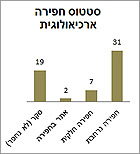
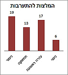
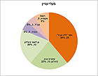
The intervention recommendations were formulated on the basis of the sites’ physical condition, their potential for display and identifying an agency that will assume responsibility for further treatment of the site (Fig. 8). About 40% of the sites, 25 of the 59, are located in areas of the Nature and Parks Authority, in national parks and nature reserves. At eight of these sites, the synagogue is the reason the site was declared a national park (Fig. 9). Eleven sites are in areas managed by local authorities, the church and the Jewish National Fund, and the 23 other sites, constituting c. 40% of the total, remain to this day without any responsible agency being directly involved in their preservation (Fig. 10).
Faced with this situation, one of the project’s main challenges is promoting collaboration with the Nature and Parks Authority, local authorities and other stakeholders interested in these “orphan” sites, in order to ensure ongoing conservation activity in them that will include the establishment of a long-term maintenance system and the development plans for tourism, education and community involvement.
An example of this is the activity in the Golan, where we know of about 30 sites where there are synagogues, a concentration unmatched anywhere else in the country. The monumental buildings are constructed of neatly dressed basalt ashlar stones and the magnificent artistic decorations are in an excellent state of preservation. In the wake of the rescue project, the Golan Regional Council has taken upon itself the task of formulating a master plan for the conservation and development of the ancient synagogues in the Golan. In addition, the Golan Regional Council, Israel Antiquities Authority and Heritage Program in the Prime Minister's Office have initiated a community education program relating to the ancient synagogues.
Another aspect of the plan of action includes making the information accessible to the public. To this end, we are working to establish a digital place-based system that will raise awareness of the existence of the sites among the visitors located in the region. It will use AR technology and means of collaborative platforms.
Implementing Rescue Work at the Sites
A special conservation team was established to perform the work, and documentation and a conservation survey were conducted at every site which served as a basis for the conservation plan. As of February 2015 conservation work has been done in the synagogues at ‘Ein Nashut, Meron and Gush Halav. Other work is planned for Horbat Shema, Yesod Ha-Ma‘aleh, Horbat Kanaf, Dabbia and Tel Iztabba.
‘Ein Nashut
Horbat ‘Ein Nashut, located c. 2.5 kilometers north of Qatzrin, was excavated in 1978 by Z.U. Ma‘oz, who in addition to the synagogue exposed two oil presses there (Ma‘oz 2010). The synagogue was used during the fifth–sixth centuries CE and its allure lies in the wealth of architectural items, capitals, columns and decorations which are among the most beautiful and magnificent discovered in the Golan. The items were transferred for display to the Golan Antiquities Museum in Qatzrin, while the remains of the synagogue were left exposed to the elements. Although conservation measures were carried out in the building in 1999, there is no regular maintenance of the structure and its physical condition has deteriorated. The roots of raspberry and caper bushes that penetrated into the walls have caused the plaster floors and the mortar in the walls to crumble (Fig. 11). By 2013 the condition of the site necessitated immediate intervention. During the conservation work the dense vegetation that had spread throughout the site was removed, pits were filled in and drainage was installed along the tops of the walls to prevent water from seeping into the core of the wall (Fig. 12). The work was performed employing traditional materials and technologies suitable for the stone construction and utilizing lime-based mortar. The plaster edges of the floor that kept crumbling were reinforced with new plaster, and the spaces in the joints between the building stones were cleaned and filled with mortar. These measures were designed to slow the process of deterioration and destruction and now, upon completion of the work, the conservation of the site is stable (Fig. 13). When the stabilization work was finished the Golan Regional Council assumed responsibility for maintaining the site, as well as planning of walkways and signage, in order to open the site to the public.
Meron
More than one million people visit the tomb of Rabbi Shimon Bar Yochai annually, but few are aware of the ancient synagogue situated at the top of Horvat Meron. Pilgrims and Jewish travelers mentioned the remains of the ancient synagogue in medieval historical sources, as one of the 24 synagogues that were “built by Rabbi Shimon Bar Yochai”. In the 1960s staff from the Department of Antiquities and Museums reinforced the original main entrance of the synagogue and rebuilt its eastern opening (Stepansky 2014). In 1971–1977 excavations were conducted at the ruin, directed by E.M. Meyers, C.L. Meyers and J.P. Strange (Meyers, Strange and Meyers 1981). The synagogue’s magnificent facade was preserved to the height of the lintels, and according to the tradition of the Jews of Safed, when the synagogue’s lintel will fall (by itself!) “Our messiah will come quickly” (Herzberg, Gabbay and Stepanski 2011). The structure is hewn in a bedrock terrace and its eastern side is supported by a built wall. A conservation survey revealed that the retaining wall was at risk of collapse and the site suffered from neglect and vandalism. The conservation work included clearing the vegetation that took root in the walls and floors, stabilizing the entire length of the retaining wall and cleaning the graffiti from the bedrock walls and façade (Fig. 14), in addition to which, the steel and concrete supports added in the 1960s were treated (Fig. 15,16). Girls from the ulpana (religious school) and boys from Yeshivat Benei Akiva, both located next to the synagogue, and the staff, followed the conservation work with great interest and helped with the cleaning and logistical support. In the wake of the activity at the site the yeshiva is taking the initiative to create an ‘Adopt-a-Site’ education program along with an initiative of the Nature and Parks Authority to open the place to the public.
Gush Halav
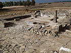
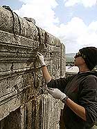
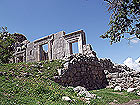
The ancient synagogue is located on a slope in the pastoral landscape of Nahal Gush Halav, at the foot of Jish. The place was mentioned in the surveys of the nineteenth century, but the first scientific study of it was carried out in 1905 by Kohl and Watzinger. It was completely excavated in 1977–1978 by an American expedition headed by E.M. Meyers, C.L. Meyers and J.P. Strange (Meyers, Meyers, and Strange 1990). Subsequent to the excavation of the synagogue, some of the building’s columns were put back on top of their original bases (Stepansky 2014). The excavation revealed a synagogue structure consisting of a central prayer hall surrounded by three narrow annexes. Two rows of columns divide the space into a nave and two aisles. A single opening is fixed in the center of the front wall in which there is a lintel decorated with a special relief of an eagle with spread wings flanked by garlands.
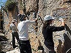
The conservation survey found that since its excavation in the 1970s, the building has not undergone any conservation treatment and its physical condition has deteriorated. Hawthorn trees and caper bushes grew inside the walls and the mortar crumbled to the point that parts of the walls collapsed. Extensive conservation work included removing vegetation, cleaning the crumbling mortar from the joints and the core of the wall and filling them with new earth and hydraulic lime-based mortar (Fig. 17, 18).
Conclusion
The rescue project of the synagogues allowed us for the first time to build a model of a system for managing heritage resources with a long-range regional perspective. The model was designed with an integrative approach that takes into account the rescue of the sites from the physical aspect of stabilizing and conserving the buildings, from the ethical aspect of “saving the knowledge” and making it available, and from the public-educational aspect of community collaboration. The rationale behind the model is based on the recognition that awareness and appreciation of the synagogues and their surroundings by the general public, local communities, agencies and the other stakeholders is a pre-requisite for their physical conservation and long-term maintenance.
References
Levine L. I. 1999. The Ancient Synagogue: The First Thousand Years. New Haven/London: Yale University Press.
Ma‘oz Z.U. 2010. ‘Ein Nashut: The Art and Architecture of a Synagogue in the Golan. Qazrin.
Meyers E.M, Strange J.F. and Meyers C.L. 1981. Excavations at Ancient Meiron, Upper Galilee, Israel 1971-72, 1974-75, 1977. Cambridge, Mass.
Meyers E., Meyers C.L. and Strange J.F. 1990. Excavations at the Ancient Synagogue of Gush Halav (Meiron Excavation project 5), Winona Lake, Indiana.
Herzberg J. Gabbay J. Stepansky Y. 2011. Holy Places and Tombs of the Sages in the Galilee (Second Edition), published by the Ohalei Tzadikim Association. Jerusalem. Volume II, pp 107–112 (Hebrew).
Stepansky Y. 2014. Handouts on Synagogues for the Rescue Project. Not published (Hebrew).
------------------------------
The Israel Antiquities Authority Conservation Department is implementing the project with financing provided by the Landmarks Israel in the Prime Minister’s Office. Yael Alef is the project coordinator assisted by Amit Rosenblum (chief conservator), Eran Hemo (Projects Department director), Raz Efron (Planning Branch director), Yoram Sa‘ad (Implementation Branch director, Conservation Administration), Dina Avshalom-Gorni (Eastern Galilee district archaeologist), Oren Zingboym (Golan district antiquities inspector), Gilad Cinamon (Lower Eastern Galilee district antiquities inspector), Uri Berger (Eastern Galilee district antiquities inspector), Zach Horowitz (Lower Galilee and Valleys district archeologist of the IAA Northern Region), Iris Hadar, Dorit Harel and Zohar Ya‘aqobi – information technology staff (Planning Coordination and Control Administration, ).
We would also like to thank the Israel Nature and Parks Authority and the Golan Regional Council.
------------------------------
August 2015
To view the figures, click on the figure caption
|
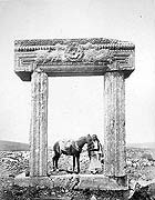 |
1. The northern synagogue of Bar‘am, from surveys conducted in the nineteenth century. In this picture by the PEF a magnificent in situ portal that has a decorated lintel with a Hebrew inscription.
|
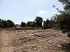 |
2. The northern (small) synagogue of Bar‘am today. A few of the walls from the excavation in 1998 and a fragment of a decorated doorjamb that survived in the field can still be identified.
|
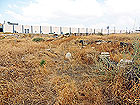 |
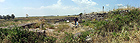
3. A synagogue at Tel Iztabba (Sehuta) today. The mosaics are displayed in the Israel Museum, and the site remains neglected and destroyed as a result of the ravages of nature and man.
|
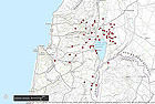 |
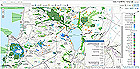
4. The survey map of the synagogues. Source: the conservation inventory of ancient synagogues in the Galilee, Conservation Administration – Israel Antiquities Authority.
|
 |
5. Distribution of the data regarding the status of the archaeological excavation at the sites.
|
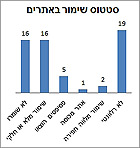 |
6. Distribution of the data regarding the conservation status at the sites.
|
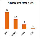 |
7. Distribution of the data regarding the physical condition of the sites.
|
 |
8. Distribution of the recommendations for the types of intervention at the sites.
|
 |
9. GIS map with the synagogue sites against the areas where there are nature reserves and national parks.
|
 |
10. The stakeholders at the sites.
|
 |
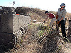
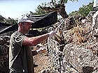
11. The synagogue at ‘Ein Nashut. Oren Zingboym, IAA Golan district antiquities inspector, in the conservation survey. A site where dense vegetation takes root that destroys the floors and walls.
|
 |
12. The synagogue at ‘Ein Nashut. Conservation team members began their work in the prickly fight to remove the raspberry and caper shrubs from inside the walls and floors.
|
 |
13. ‘Ein Nashut, general view of the synagogue upon completion of stabilization work. Photographic credit: Amit Rosenblum 2014.
|
 |
14. The synagogue at Meron, cleaning graffiti (“Na Nach Nachma Nachman from Uman”) from the bedrock wall of the building. Photographic credit: Yael Alef in 2014.
|
 |
15. The synagogue at Meron. Treating the steel and concrete supports from the 1960s and conserving the center opening in the façade. Photographic credit: Amit Rosenblum 2014.
|
 |
16. The synagogue at Meron. Looking northwest at the retaining wall and the façade upon conclusion of the conservation work. Photographic credit: Amit Rosenblum 2014.
|
 |
17. The synagogue in Gush Halav. Hawthorn trees and caper shrubs took root in the walls. The conservation team, sprays herbicides on the roots of the caper in order to prevent it from growing again.
|
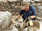 |
18. The synagogue in Gush Halav. Amit Rosenblum, head of the conservation team, completes missing stones during the work to stabilize the top of the wall.
|
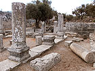 |
19. The synagogue in Gush Halav upon completion of the stabilization and conservation work. Photographic credit: Amit Rosenblum 2014.
|
|