|
| Ancient Yodefat |
| Conservation and Development of the Site |
| Implemented by: |
Eran Mordohovich
John Peterson
|
The conservation and development of the Ancient Yodefat site is an initiative of the Nature and Parks Authority, funded by the Milestones Program of the Heritage Division of the Prime Minister's Office, in collaboration with the Misgav Regional Council and the Israel Antiquities Authority. The goal of the project is to conserve the important archaeological finds, make the site accessible to a wide audience, illustrate the findings for the visiting public and install explanatory and guidance signage at the site.
Ancient Yodefat will remain a nature and heritage site open to visitors.
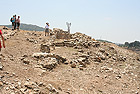
Solid physical evidence for three main stories was found in archaeological excavations directed by archaeologist Mordechai Aviam on the mountain in the 1990’s:
• The story of the Galilean farming town in the first century CE (the Early Roman period)
• The story of preparing for the rebellion and fortifying the city by Josephus, the leader of the uprising in Galilee
• The story of the Roman siege in the summer of 67 CE and the tragic end of the town and its people
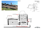
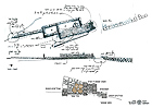
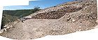
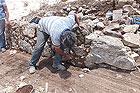
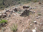
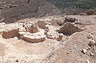
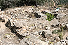
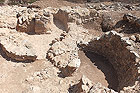
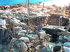
Finds that express these stories were selected during the conservation process. These finds include dwellings with ritual baths (miqwa’ot), an oil press, a potter’s kiln, a residential building that has a hiding refuge located beneath it, various segments of the city wall and cisterns that were used after the battle in which hundreds of victims of the Roman massacre were buried.
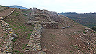
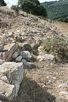
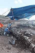
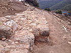
The city wall, which is more than one kilometer long, was built utilizing different construction methods and is in various states of preservation. Most of the archaeological sites that have survived are near the city walls or are part of them. These enhance the importance of the walls. Accordingly, the conservators sought to highlight the route of the walls and conserve as many of their large segments as possible.
By emphasizing the structures through the physical intervention of conserving the site and illustrating the story by means of explanatory signage, quotations and Josephus’ writings that describe in detail the history and end of the town, the planners sought to expose visitors to all aspects of the story about the site, as well as the remarkable nature and landscape values of the place.
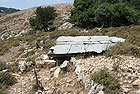
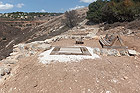
The landscaping included the preparation of parking facilities for buses and private vehicles and parking for the handicapped. At the start of the visitor’s path a shaded area will be prepared where visitors can assemble and signage will be posted with general information about the site. In addition, paths accessible to the handicapped and a moderately inclined track that leads up to the top of the mountain will be set up. A dirt path was built between the different archaeological sites and wooden steps are incorporated in it making it easier to walk there.
Potential to Continue the Project. Althoughthe IAA conservators treated quite a few segments of the city walls, given the allocated budget it was not possible to conserve the entire route of the wall. Highlighting the route of the wall is an important measure that can greatly enhance the site, and is not complex from the standpoint of engineering or conservation. This intervention can be done with the help of the community, under the supervision of archaeologists and conservators.
The proposed measure promotes the continued conservation and maintenance of the site with the assistance of local communities. This framework includes publicity and familiarizing the public with the site in general, and the walls in particular; involvement in the conservation and maintenance: placing stones back in the wall, replacing several stones and securing them in the wall with mortar akin to the original mortar that was used. Such measures are inherently multi-year and multiage if done in collaboration with members of the communities and the schools in the area, and they can increase the community’s connection to the site and contribute to its preservation and upkeep over time.
- - - - - - - - - - - - - - - - - - - -
Developer: Nature and Parks Authority, Milestones Program of the Heritage Division in the Prime Minister's Office
Accompanying archaeologist: Mordechai Aviam
Conservation planning and implementation: Israel Antiquities Authority Conservation Administration (Architect: Eran Mordohovich, Conservator: Johni Peterson)
Landscape design: Landscape architect: Eran Ga‘ash, Ya‘ad Architects.
Signage and illustration design: Studio Y, Yodefat.
Project management: Gilad Diamant
- - - - - - - - - - - - - - - - - - - -
August 2015
To view the figures, click on the figure caption
|
|