| Yoqneʽam |
| Tel Yoqneʽam |
| Adopt-a-Site Project |
| Implemented by: |
Arch. Yaara Shaltiel
Arch. Eran Hemo
Arch. Michal Ratner
John Peterson
|
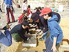
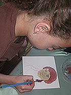
Since 2007, the Israel Antiquities Authority and Yoqneʽam municipality have been engaged in a process of sustainable development and conservation on Tel Yoqneʽam. The measures undertaken in 2012 and 2013 were done so with the support of the Milestones Program of the Heritage Division in the Prime Minister’s Office. During this process the archaeological remains were conserved, including those of the church and the city wall, information stations were developed and visitor’s paths were prepared. Fourth grade pupils in the elementary schools also participated in the process. The students left their own individual mark in the form of a personal ceramic tile that was integrated in the signage on the tell, and they assisted in preparing mud bricks used in the rehabilitation of the ancient fortifications
The preservation processes in which the community is involved allow local residents to become acquainted with the values of the place, understand their importance, develop a sense of local pride and a connection to the place, and as a result of all these, take responsibility for the place. The process begins with recognition of the place’s values, both tangible and intangible and with manifestations in the field. In that way the community learns and teaches the significance of the values of the ‘place’, the importance of maintaining these resources and transferring them to future generations. By this stage the community starts to develop a connection with the ‘place’ and begins to develop a sense of local pride. This feeling leads to the community assuming responsibility for the values of the 'place' and the physical manifestations of the archaeological remains. The working assumption is that at the end of the process the community will be responsible for the ‘place’, including the local authority which will assume a commitment to maintain the 'place'. This process promotes environmental civic leadership. These ideas are reflected in the process of the "Adopt-a-Site" program such as that which has taken place for several years at Tel Yoqneʽam.
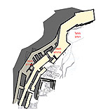
Two sets of fortifications were uncovered on the tell, one atop the other, dating to the Iron Age II. The earlier city wall (ascribed to the Iron Age IIA – tenth century and beginning of the ninth century BCE) is a casemate wall. The wall is built of adjacent rooms that could only be reached from inside the city. These spaces were used as dwellings, workshops and for storage. In times of war the spaces were filled with soil in order to strengthen the city wall. At the beginning of the ninth century BCE the size of the city was reduced. But at the end of the century and during the eighth century BCE a developed settlement was renewed there.
A corridor wall was constructed on top of the remains of the casemate wall. It was a minimum of five meters wide and the residential structures adjoined it. The wall probably surrounded a water system that was not entirely excavated, and the drainage channel found next to it was constructed as part of the wall. The corridor wall is characterized by a long narrow passage meant to allow movement between the confines of the city wall. The corridor was entered by way of an opening that faced the peripheral street which separated the city wall from the residential buildings and open areas. Several towers were built along the wall. The towers are a widening of the wall, and their goal was to stabilize the two walls and overcome the steepness of the slope. The wall also enclosed the water system.
Meager remains of the casemate wall have survived. In the past twenty years much of its remains have collapsed because of several reasons: 1) the casemate wall was situated on upper edge of the slope, 2) its condition during the excavations, 3) the deep excavations that were done at the foot of the wall and 4) the absence of conservation.
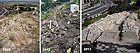
Most of the conservation and development work that was done in 2012 and 2013 involved stabilizing and displaying the remains of the corridor wall. This wall is in a better state of preservation, but there were parts of it that also stood intact at the end of the excavation which have since collapsed and tumbled to the bottom of the slope. The intensive excavation of the slope beneath the fortifications’ foundations also caused damage the sides of the mound.
In the first stage a thirty meter section of the corridor wall and several remains of the city’s casemate wall were treated. The volume of construction was relatively large and included the restoration of the outer face of the walls and completing one to two courses of the wall depending on the preserved height of the core of the walls. At the southern end we restored a short section of mud bricks that fourth graders prepared in the city as part of the community process taking place there. In the corridor between the fortification walls, we prepared a safe passageway for the public and the steps going down are built of railway sleepers. Upon completion of this stage one can descend from the observation point and advance along the 30 meters that were restored and return.
Programs meant to integrate a community in the conservation and protection process of cultural heritage lead to the creation a community nucleus that supports the conservation measures, and thereby creates widespread public cooperation for them. Such programs require a long time, a change in thought patterns and establishing the cognitive change expected from the community and the local authority for the local heritage conservation as part of its conduct in the present and in the future. Expanding community involvement from the scope of the schools to that of other involvement by the community can lead to expediting the process, solidifying and strengthening the relationship between the local community and the place, and turning it into a vibrant component in the life of the community.
------------------------------
August 2015
To view the figures, click on the figure caption
|
|