| Jerusalem |
| Derekh Hevron |
| Conservation Appendix to a Building Plan |
| Implemented by: |
Arch. Avi Mashiah
Arch. Tamar Nativ
|
Plan No. 101-0053751 for a parcel of land on Derekh Hevron, authorizes the construction of a residential neighborhood of 800 dwelling units, a public park and municipal lots. The area of the plan is bounded by Derekh Hevron in the west, Leib Yaffe Street in the east, Asher Weiner Street in the south and Revadim Street in the north. The conservation appendix for the plan that we compiled on behalf of the Conservation Administration of the Israel Antiquities Authority sets forth principles for the combined conservation and planning of archaeological sites located in the area of the plan.
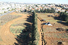
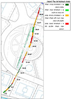
In 2010-2011 an archaeological excavation directed by Yaʽaqov Billig was conducted there prior to the construction of the neighborhood (Fig. 1). The High Level Aqueduct of Jerusalem, which traversed the planned neighborhood from north to south, was uncovered in the excavation. Following the aqueduct’s discovery it was decided to integrate the find in the neighborhood’s open spaces, the planning of which was assigned to the landscape architect Rachel Weiner. The conservation appendix presents a fundamental plan for incorporating the aqueduct in the neighborhood, as both a pedestrian artery and an archaeological park, where the aqueduct remains, its reconstructions and illustrations of water conveyance are exhibited.
The High Level Aqueduct, which was built by Roman legionnaires, dates to the Early Roman period. It begins at Solomon’s Pools, and according to what we know it passed through the region where Jaffa Gate was constructed in the Ottoman period to Herod’s palace, in the Upper City of Jerusalem. Before the water entered the city it flowed into Mamilla Pool whence it was conveyed to Hezekiah’s Pool.
The construction technology utilized in building the High Level Aqueduct varies the length of it. Most of the aqueduct is built above ground; in some sections it is rock-hewn and in others it is composed of stone sections.
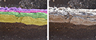
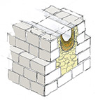
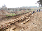
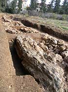
The aqueduct’s remains in the planned area referred to here are built above ground. Its base was originally c. 1.5–2.0 m wide and it also stood c. 1.5–2.0 m high. On top of the base is a wide channel that was made narrower over the course of time due to multiple layers of plaster that were applied on top of each other (Fig. 2, 3). The state of preservation of the aqueduct that was exposed ranges from poor to mediocre (Figs. 4, 5). It survived to a maximum height of three courses and its western side is missing. On parts of it one can see that the channel that was just 15 centimeters wide where it was made narrower by the many layers of plaster. The aqueduct’s cover was not preserved. Two segments of the channel that had collapsed on their side, probably as a result of an earthquake, were exposed some two meters from the line of the aqueduct. A terrace that was built of flint after the aqueduct ceased to be used abuts its western side.
The aim of the planning was to integrate the remains of the High Level Aqueduct in the area of a public park and thereby preserve its story and add historical content and scenery to the park, for the benefit of the residents.
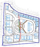
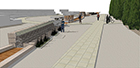
The Aqueduct’s Route: The route of the aqueduct and its continuity are of historical value with regards to the development of the city. However, the aqueduct’s remains are located below the future level of the public park, and therefore they cannot be completely preserved. Because of these circumstances it was decided; 1) to preserve the uninterrupted route of the aqueduct by marking it along the level of the public park; 2) to expose the aqueduct partially and 3) to emphasize its presence by means of turning its route into a neighborhood pedestrian artery (Figs. 6, 7). An exhibit of the aqueduct will be erected along the artery and the marked route of the aqueduct will serve as a thread that will connect its remains. The exhibit in the middle of the park will include sections of the aqueduct that were moved from their original location, other archaeological elements, as well as a restored section of the aqueduct.
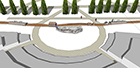
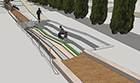
Exhibit Items: The exhibit along the pedestrian artery will be divided into a main segment and two segments to the north and south. The main segment is located at an intersection of paths in the park, and will therefore have maximum exposure. A restoration of a working segment of the aqueduct and all of its parts will be displayed which will demonstrate Jerusalem’s water system (Fig. 8). In addition, a relief map depicting the routes of the aqueducts from Solomon’s Pools to Jerusalem will be presented. The water that will flow in the restored segment will also be utilized in the relief map. Segments of the aqueduct that underwent conservation will be moved from their original locations and will be exhibited in the northern and southern displays. These segments were carefully selected and they represent the original construction technology and the sequence in the aqueduct’s use. The two segments, c. 8 m long, will be positioned on the level of the park, along the aqueduct’s route where it is marked on the ground (Figs. 9, 10).
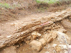
In addition, the plan proposes conserving sections of an aqueduct at their original level, in the municipal lots located north and south of the public park. Well-preserved sections of the aqueduct survived in these places: in the north there is a collapsed section of an aqueduct (Fig. 11) and in the south there is section in which the aqueduct’s channel is covered with multiple layers of plaster. Benches arranged in a terraced manner, which will look out over the aqueduct, were planned adjacent to these sections (Fig. 12).
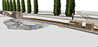
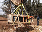
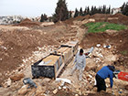
The Situation as of January 2013: Work is being carried out to prepare the area for the residential buildings and the public spaces. The two sections of aqueduct (Figs. 13, 14) that were relocated and the stones of the aqueduct that were dismantled are currently being kept in the IAA storerooms. Upon completion of the infrastructure work and the start of the development work of the public park, conservators of the IAA Conservation Department will treat the sections of aqueduct that were moved and return them to their place in the park. They will erect signage and other accompanying furnishings there that explain the artifacts.
-------------------------
January 2013
------------------------
To view the figures, click on the figure caption
|
|