| Gush Halav |
| Jish |
| Urban survey |
| Orderer | Project Delta – Israel, Gush Halav Local Council |
| Duration | May – October 2005 |
| Implemented by: |
Arch. Faina Milshtein
|
The urban survey that was performed in the village of Jish, Gush Halav, was conducted within the framework of the Delta Project. The purpose of the survey is to serve as a pilot for identifying a cultural resource that when reinforced and integrated with the development of tourism will economically aid the place and promote the welfare of the residents. Given the insight that was gained in the wake of the survey, its recommendations will be incorporated in the master plan and other surveys and documentation of buildings and traditional elements will be promoted for the sake of conserving the heritage of the village as part of its development.
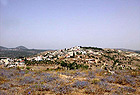
The village is located on the lower southern slopes of a hill rising up in the Upper Galilee, c. 4 kilometers northeast of Mount Meron, next to Nahal Gush Halav, and is an integral part of the breathtaking landscape of nature reserves and agricultural areas that surround it. The Nahariya – Safed road winds its way past the main entrance to the village where Maronite Christians, Catholics and Muslims live.
The village was inhabited from Biblical times until the modern era. The urban landscape of the village consists of a historic district c. 200 years old, very well preserved archaeological and architectural remains, new neighborhoods, industrial zones and traditional and modern cultivation plots. The village is of cultural, historic, archaeological, architectural and humanist value.
Cultural and Social Aspects
Gush Halav (Jish) is one of the authentic focal points in the cultural landscape in the Upper Galilee. The cultural importance of the village is linked to an assemblage of characteristics that include the geographic and topographic location, a rich history which is documented in numerous written sources, the diverse archaeological and architectural finds, the existence of agriculture and traditional crafts, and the local population.
Gush Halav was a regional center for thousands of years. The history of the place is part and parcel of the collective memory of the three religions in the Land of Israel and hence its social importance. A multi-cultural and educated community resides in the village and inspires an atmosphere of openness and security that accompanies the visitors there.
The Historical Aspect
The most ancient finds that were discovered in the village are 4,500 years old and this is one of the only places in the country where there has been uninterrupted settlement for more than 3,000 years.
The Biblical Period. Gush Halav is mentioned in the Mishnah as one of the cities “surrounded by walls since the time of Joshua Ben Nun”.
The Second Temple Period. This is one of the most important settlements in the Upper Galilee. During the revolt against the Romans the city was fortified (apparently the area of the tell) by Yohanan Ben Levi, also known by the name Yohanan of Gush Halav, who was one of the rebel leaders. The city was not destroyed in the revolt against Rome because it surrendered voluntarily.
The Roman-Byzantine Periods. The impressive archaeological finds from these periods, including two synagogues, a unique mausoleum and burial caves, indicate that in the first centuries of the Common Era there was a rich and flourishing settlement here. In the excavations that have been conducted on the tell no evidence of fortifications have been found to date.
The Middle Ages. During the Islamic period the settlement was called Jush or Jish. Various historical sources from the 10th, 11th, 12th-14th and 15th centuries CE mention that Gush Halav (Jish) was a large Jewish village.
The Seventeenth Century. We know that Druze lived there during this century and they left the village at some later stage.
The Mamluk Period. Buildings from this period were erected on top of bedrock on the southern slope of the hill; some of them are preserved to this day.
The Ottoman Period. At the beginning of the 18th century Maronite Christians, Catholics and a number of Muslim families settled in Jish. In 1837 an earthquake struck that destroyed most of the village’s buildings and caused the death of c. 200 people. Following the earthquake the village was re-inhabited and it spread to the southern slope. This construction, which dates to this period, is currently the historic core of Gush Halav and is very well-preserved.
The Modern Era. In 1948 many of the residents left Jish and inhabitants from the neighboring villages that were destroyed arrived in their place.
Today’s Jish is a vibrant village that is dynamic both from an urban and human standpoint. There is built evidence of the village’s history. The village is today inhabited by Maronite Christians and Greek Catholics and about one-fifth of the residents are Muslim.
The Archaeological Aspect
The rich archaeological and historic finds characterize the village and it is fertile ground for tourist development. Eighteen archaeological sites have been excavated to date in Gush Halav and the nearby vicinity. Ten of them were documented archaeologically but no conservation measures were implemented in them; some were covered over and are not displayed to the public. Eight sites were documented and conservation measures were carried out in the past and the sites are today open to the public; five of them are in a state of neglect.
Among the finds present there are the remains of two magnificent synagogues that date to the Roman and Byzantine periods and a unique mausoleum from the 4th century CE with a double sarcophagus on top of it. There still remains much archaeology to be researched and studied on the tell. The research value of Gush Halav can help expand our knowledge about the Upper Galilee and the Land of Israel and there exists potential additional research that awaits investigation.
Environmental Aspects
The geographic location of the village on a lofty hill situated at a cross-road has conferred strategic importance upon it throughout history. From a landscape standpoint Gush Halav is an integral part of the nature reserve that envelops it. Nahal Gush Halav passes northeast of the village and along the river are the remains of six traditional flour mills that bestow it additional value.
The presence of so many sources of water in and around the village has contributed greatly to the flourishing of agriculture and traditional crafts. The appearance of Gush Halav is characterized by its uniting with the nature around it, and in the background is the landscape of Mount Meron with all of its cultural significance. Breathtaking views of the village can be seen from different locations in the vicinity because of its setting on a hill. The traditional farming plots delineated by stone retaining walls, terraces and traditional and modern farming areas surround the village and they are part of the cultural landscape.
Urban Aspects
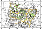
The historic core of Gush Halav is delimited by the main roads around it. This delineation has contributed to preserving its urban character. The village’s appearance is characterized by low construction that blends into the topography and a church structure that stands out prominently along the skyline. The urban structure conforms to two factors: to the landscape which envelopes the place and the traditional life styles.
The landscape factor is manifested by the open space – the network of roads whose axes are directed outward and continue to look out over the landscape; the second factor finds expression in the built-up space – the traditional buildings, whose plan is directed inward, to the inner courtyards that are the center of family life.
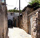
The urban structure is integrated in the topography: the historic core is built in the shape of a rectangle along the contour lines; the main roads run parallel to or perpendicular to the contour lines. Winding alleys divide the quarters into blocks or “neighborhoods”. The urban plan of Gush Halav is both orderly and organic. The main arteries delimit the historic core from all four sides: a main street running north south divides the area into two quarters: on the west – the Christian quarter and on the east the Muslim Quarter. Situated in the heart of each quarter is a religious structure that acts as a planning “anchor” and next to it is a main street that divides the quarter into two parts; the street is typified by a uniform, modest and fortified style. The walls of the buildings define the area of the street. These were mostly constructed without window openings and have only arched entrance gates that lead to inner courtyards. The fortified and minimalist nature of the traditional street reflects the traditional life that is focused inward and emphasizes the richness of the landscape and draws one’s attention to it.
Architectural and Technological Aspects
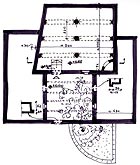
The built-up area in Gush Halav consists of basic units of traditional residential buildings. Clusters of several units create built groups of blocks and neighborhoods. Most of the buildings were erected after the earthquake of 1837. The fine preservation of the buildings makes it possible to reconstruct the architectural and engineering plan of the traditional house in the village and also the interior design.
Studying the village core included a preliminary survey of 36 buildings that are of architectural value, six abandoned buildings and six deserted regions with impressive remains of architectural elements. In most of the buildings that were surveyed the plan, as well as typical and unique architectural details, was preserved that should be fully documented.
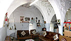
The typical house is characterized by a courtyard house plan, similar to residential buildings in many cities and villages in the Mediterranean basin. The dwelling is divided into regions and levels meant for the family members and animals, in accordance with the difference uses that typify village life. The inner courtyard is the center of the house, the center of family activity and where all traffic passing through the structure intersects. In most instances the courtyard in Gush Halav is in the front of the building and functions as a partition between the public and private areas. It is delimited by a massive wall with an entrance gate which separates the house from the street. There are usually vine arbors in the courtyards which confer shade, tranquility, beauty and privacy upon them. Plaster decorations in geometric forms adorn the columns and the traditional ovens inside the structure, something which is also characteristic of other villages in the Upper Galilee.
The building of the residential structures is a model of stable construction in steep topography, which can even withstand earthquakes. Its characteristics include low distinct and functional construction that limits damage at the time of an emergency; stone walls 70-80 cm wide that surround the building on all sides; and one to four rows of stone structural arches that rest on the walls and a central circular column. These arches divide the space and reduce the roof span; most of the roofs of the buildings are made of tree branches. In some of the buildings the roof consists of groined and barrel vaults; walls acting as a counterforce provide stability to the buildings situated on a steep slope when a narrow elongated rectangular space of massive stones is built in the rear facing the slope. This component fulfills a number of functions: it prevents dampness from penetrating into the wall of the residential space and offers support during an earthquake. The space is mainly used for storage.
Principal Recommendations for Future Planning
We recommend adopting the principals of traditional construction for the urban and architectural planning of the historic core and the new neighborhoods in the village:
Harmony rather than competing with nature: protect the village’s unique skyline and accentuate the topography and important public/religious buildings;
A Rural and Modest Construction Style that blends in with nature while limiting the height of the buildings to two stories with flat roofs;
Plans should conform to the topography – to the contour lines and the wind directions;
Opening up Traditional Views that are blocked from the landscape;
Construction of Small Neighborhoods that conform to nature, topography and the life style of the village;
Family Privacy: In conversations conducted with the residents they mentioned that the inner courtyard is still important from a cultural standpoint today. It is imperative that future planning protect this component in the dwelling unit. The character of the rural construction also deserves to be maintained, including separate residential units for each family, in accordance with the cultural perception of the local population;
Continuing to design architectural items and elements that are typical of the village;
Using delicate pastel colors rather than harsh colors in designing a new building and street;
Planning underground infrastructure systems that are not visible along the landscape;
The route of the roads in the planned neighborhoods should conform to the topography in such a manner as to blend with the natural landscape so that they do not alter it.
General Conclusions
· Integrating the data presented in this survey in the master plan will further the protection of the village’s built heritage, and is likely to contribute to saving the remains of the cultural, urban and architectural landscape, and the authenticity of the place.
· The state of preservation of the village’s historic core facilitates analyzing and understanding the traditional construction in Gush Halav, in particular, as well as in the ancient villages in the Upper Galilee, in general.
· The urban survey contributed to formulating conclusions and guidelines for the conservation, restoration and development of the village’s historic core and other villages in the Upper Galilee.
· The advancement of heritage-based tourism here is likely to contribute to the development of the village’s economic infrastructure and encourage the local residents to remain here.
List of Recommendations
· Act to reinforce the legal protection of the cultural assets by emphasizing conservation in the master plan.
· To preserve, renovate, develop and present the village’s historic core and the important sites in its vicinity by creating a series of links between them through the use of tourist tracks dedicated to a variety of topics.
· Preserving the rural Mediterranean character of Gush Halav, by creating a legal framework for construction that safeguards the original and unique historic, urban and architectural values of the place, while raising the standard of living and quality of life of the residents and enforcing the statutes with regard to illegal construction.
· To create a system that fosters conservation in both the formal and informal education systems among all the local population levels. An extensive and detailed educational program with respect to the different aspects of the material and non-material heritage assets can contribute to raising awareness thus resulting in the conservation of the cultural assets, the promotion of tourism and the improvement in the quality of life in the village.
· The participation of the local community in future archaeological excavations; in the documentation, conservation and restoration of sites that are of historic and architectural importance; and also the study and restoration in the traditional fields of agriculture and crafts; establishing workshops to study aspects of traditional life such as construction, farming, food and industry.
· Extensive tourism development that is sensitive to the heritage values based on the model developed in the Delta Project for advancing the economic value of the village.
· To establish in future planning the matter of conservation and maintenance as a branch on which both tourism and the economic development of the village can rely.
· Integrating the antiquities sites in the planning of future development.
· The development plan will include conservation, tourism and presentation of the heritage sites to the general public.
· Creation of a visitor’s center, a museum for presenting the social history of the village and an archive for documents and photographs that are of historic and topical interest.
· Conservation, environmental development and maintenance of the archaeological and historic sites that can be visited today.
· Conservation and development of the 4th century CE mausoleum as a main tourist focal point.
· Examining the possibility of exposing archaeological sites that were covered over, such as the Byzantine tomb, and preparing them for display.
· Preparing archaeological gardens around the lower synagogue that dates to the Roman period and around the tell, and placing valuable architectural items from a number of periods on display.
· Conservation and partial reconstruction of the flour mills in Nahal Gush Halav and exhibiting them to the public.
· Preservation of the historic core’s original urban plan by withholding permission to create new streets or alleys.
· Preservation of the village skyline and the creation of a legal framework that limits the height of new construction.
· Conservation and restoration of streets based on their original characteristics.
· Conservation and maintenance of historic religious buildings in and around the village, such as churches, mosques and the tombs of sages.
· Creating a system for the detailed documentation of typical and rare architectural elements.
· Conservation and restoration of residential buildings that are of architectural value.
· Restoration and making use of areas and deserted buildings in which there are impressive remains of architectural elements. The abandoned places have urban and architectural potential for development which can be used to increase the number dwelling units in the village’s historic core, as a museum, visitor’s center, classrooms and workshops.
· Development of tourist tracks according to topics, such as history and archaeology; religion and co-existence; traditional rural family life; traditional and modern farming and crafts; relations between the village and nature.
· Integrating lookouts in the tourist tracks including observation points from which one can view the entire village, parts of it and the breathtaking landscape that opens up before it. We recommend that the lookouts be planned as shaded rest areas that include signage explaining the location, geography, landscape and history.
· Posting explanatory signs and preparing a guidance system for the convenience of the visitors (we recommend designing a guidance/tourist track feature such as making the pavement out of a different material, form or color).
This survey outlines the basis for the conservation and development of the ancient core of Gush Halav and the important sites in its vicinity by means of conservation, restoration, development, presentation and planning of diverse tourist tracks (organized and/or spontaneous). Incorporating the survey conclusions in the master plan will further protect the heritage while at the same time develop the village and raise its residents’ standard of living.
To view the figures, click on the figure caption
|
|