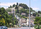
| Safed |
| Safed, The Citadel Garden |
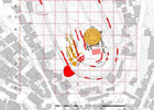
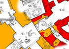
| To document the citadel in Safed |
| Orderer | The Infrastructure and Tourist Development Administration, Safed |
| Duration | February-March 2004 |
| Implemented by: |
Arch. Amir Freundlich
|
The purpose of this documentation was to describe the different components of the citadel and their distribution on Citadel Hill. It is also intended to evaluate the site, as well as propose ideas for the restoration of the citadel and its development phases as a basis for planning further research and development at the site.
The citadel constitutes an urban landmark in Safed. It is situated in the center of the old city, in a commanding topographic location that provides it with all of the characteristics of an acropolis. The site functions as an open area located in the heart of the crowded Orthodox tapestry of the city, a tapestry that highlights the qualities of the place, as well as the landscape which makes it unique.
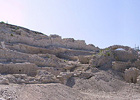
The archaeological research of the Safed citadel has only just begun. Nevertheless, the known remains and their analysis are sufficient enough for us to appreciate the size of the fortress and its architectural traits. In its northern part architectural elements were exposed that are impressive by any standard: the round tower and bell-shaped cistern below it, the Crusader water cistern, the Crusader inner wall and the arrow loops, the Mamluk gate tower and the ramp leading up to it, the secret underground passage way etc.
Following the creation of the state in 1948, a city park was created on top of the Crusader and Mamluk citadel remains, which was planned by the landscape architect, Shlomo Oren. The park incorporates within its area a variety of flora, observation points overlooking points both near and afar and a memorial to the soldiers that fell in the War of Independence.
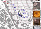
There is evidence of fortifications in Safed that date from the time of the Second Temple. Nevertheless, the remains that are exposed today are from the Crusader, Mamluk and Ottoman periods. Very important historical evidence exists regarding the first two periods, one from the bishop of Marseilles, Benova D’Avigone, describing in detail the system of fortifications dating from the middle of the 13th century CE and the second is Shams A-Din al Otmani’s account that describes the building additions by the Baybers during the second half of the same century. From an analysis of the historical evidence and the archaeological research it is apparent that the Crusader fortress extended across an area of c. 40 dunams, an area larger than that of the park today. It was comprised of two defensive rings. The fortress was defended by an outer ring of seven towers. At least two more towers were added to the Crusader fortress after the Mamluk conquest. One was a monumental round tower that was probably the victory tower located in the northern part of the fortress. The other is the gate tower that was probably erected in order to maintain contact with the Mamluk settlement which rose up southwest of the citadel. Over the course of its history buildings and fortifications were added to those from the Mamluk and Crusader periods. It is apparent that these additions utilized the earlier remains as a foundation and were not planned as military architecture.
The Safed citadel ceased to function at the beginning of 1837 following the strong earthquake that struck the city. From that point on the citadel’s remains were methodically plundered by the city’s residents who needed raw material for renovating their destroyed homes. The ruins virtually became an inexhaustible source for masonry stones and raw material used by the local lime industry. Inside the citadel garden are the remains of the cores of walls that stand as silent proof of the line of the fortress’ walls and the systematic looting that has occurred during the last two centuries. During the archaeological excavations that were conducted in the gate tower and in the inner Crusader city wall, sections of a city wall, tall walls and parts of vaults were discovered which the earthquakes have left their mark on. The remains suffer from cracking, ground settling and general collapse. Initial conservation and stabilization measures were carried out during the excavation in order to ensure the excavators’ safety. With the conclusion of the excavation, these conservation steps were completed so as to stabilize the remains in order to allow the public safe access to the ruins.
Further measures required at the site include completing a plan to stabilize the remains and a plan for presenting and explaining site to visitors that will focus on two levels: on individual elements in the citadel (e.g. arrow loops, gate) and on the building and environmental context as part of the fortress complex. We also recommended conducting a comprehensive documentation and survey of the entire fortress as a basis for conservation and stabilization planning of all of the remains that are scattered throughout the citadel garden.
To view the figures, click on the figure caption
|
|