|
| The Pasha’s Pool |
| Manof Youth Village |
| Orderer | The World Bahai Center |
| Duration | March-September 2008 |
| Address | Lot: 18050 |
| Implemented by: |
Arch. Amir Freundlich
|
The work of documenting and surveying the Pasha’s Pool was carried out in order to understand the finds at the site and identify its raw potential. The original boundaries of the garden, its components and some of its historical phases were identified within the framework of this project.
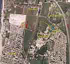
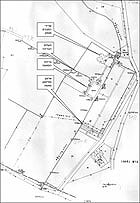
The Pasha’s Pool is located along what are today the northeastern fringes of the Manof Yad Natan Youth Village. It is bounded from the north by the Bahai Gardens (Al-Bahaj) and from the east by the ‘Atidot Institute and the aqueduct that conveyed water to Akko.
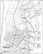
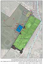
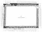
The pool extends over a slope that descends along a 5% gradient to the west (elevation: 16.5 meters above sea level in the east and c. 14.5 meters above sea level in the west). It measures 35 x 52 meters, covers an overall area of c. 1,820 square meters and has a maximum capacity of approximately 1,920 cubic meters of water.
An examination of the historical sources shows that the estate once extended across a total area of c. 208 dunams: from the manor house in the east (what is currently the ‘Atidot Institute) in the direction of the road to Tyre in the west (Highway 8510) and from the military barracks in the south (the access road to Manof and ‘Atidot) as far as the bend in the aqueduct to the west (where the Bahai Gardens are today).
The grounds of the historic estate are currently split among different institutions. Very little, if any, of the estate gardens’ installations have survived. Sewage purification facilities and oxidation pools are scattered south and west of the pool. North of the pool is an area where there is a pit that contains the ruins of stone and concrete buildings that are probably the remains of the auxiliary structures that were located on the pasha’s estate.
The documentation and survey work focus only on the Pasha’s Pool and its nearby surroundings.
The irrigation pool is referred to within the framework of this project as the “Pasha’s Pool” due to the direct association between the monument and Suleiman Pasha, governor of Akko and builder of the aqueduct to Akko. The pool was apparently built between the years 1815-1817, at the same time as the aqueduct and the adjacent palace were constructed. The change in the route of the aqueduct from that of the Al-Jazaar aqueduct, which precedes it, was done so that the former would pass through the pasha’s grounds thereby making it possible to water them. The pool was used as a supplementary installation for irrigating the nearby gardens and for the benefit of the pasha. From this we can conclude that the relationship between the aqueduct to Akko, the Pasha’s Pool and his land was intentional.
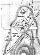
The name of the Pasha’s Garden (see the map from 1862) was a linguistic corruption of “Habaja” or “Habaji” Gardens. When the Habaja Gardens were abandoned, the Bahai Gardens to the north prospered, and the name Habaja stuck to them.
Regrettably there are very few historical sources that deal with the pool and the gardens and especially sources that refer to the events after the construction of the palace: the bequeathment of the gardens by Suleiman Pasha to his son-in-law Abdullah Pasha, and after him to Khorshid and Sa‘id Salah Amin, to the brothers Jaris and Iskandar Jamal and to the Beidan family. To the best of our knowledge today, these sources do not present the important and founding events in the history of the site and its surroundings. An exception to this is the enlargement of the estate of Abdullah Pasha to the south where the barracks and the horse stable were established (in the area of the youth village today).
Following the creation of the state in 1948 an institution for criminals (‘Atidot) and a farmstead (Yad Natan – currently Manof) were established on the grounds of the estate. In the 1970’s the land in the Pasha’s Gardens was parcelized between the two aforementioned institutions: ‘Atidot in the east and Manof in the west. This division actually separated the palace structure from the pool, as well as the upper gardens from the lower ones and thus the Pasha’s Gardens ceased to exist. The construction of the oxidation/irrigation pit at the foot of the pool on the western side cut the pool off from the orchards which were once irrigated by it. The pool now remained as a monument without its agricultural functional context.
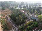
The Pasha’s Pool is one of the largest pools of its kind and period in the country. As previously mentioned, it measures 35 x 52 meters and it covers an area in excess of 1,800 square meters. The pool has a capacity of approximately two million liters.
Apart from it being a functioning agricultural installation that stored water conveyed by the aqueduct to Akko in order to irrigate the orchards below it, the pool was also used for pleasure and rest. The top of the pool, which was established at the level of the upper gardens, is splendidly paved and undoubtedly served as an extraordinary landscape promenade.
On its eastern side was the huge body of water itself and from the west there was the view of the orchards. Observers from afar, from the palace, were amazed by the majesty of the murals on the pool’s walls as were those who took shelter in the garden’s bungalows which were located in its corners (northwest and southeast) and those exploring at the foot of the garden. The water conduits that extended from the pool to the orchards were delineated at the foot of it so that the garden’s bungalows became islands surrounded by water, elliptical reflecting pools, bold colors and a pavement of river pebbles. All these and other elements undoubtedly created gardens that were an extraordinary landscape and were an unusual and unique place in the Land of Israel during the Ottoman period.
The precise manner in which the pool functioned, including its numerous openings, has yet to be fully determined. Nevertheless, it is apparent that the irrigation water was utilized for a variety of architectural and landscape purposes as they made their way to the orchards. The water was used to outline the boundaries in the garden’s landscape, the walking path in the gardens and different spots where one could stay.
In these places one would be impressed by the spectacle of rich and colorful reflections, as well as enjoy the sounds of the trickling and the flow of the water.
Despite the processes of weathering, destruction and neglect that have damaged the monument for the past forty years, the Pasha’s Pool is extraordinarily well-preserved.
The structure itself, except for three cracks in the construction that do not endanger its stability, has survived in its entirety. At the top of the pool is a pebble pavement that is one of the largest and best preserved in the country, extending across an overall area of approximately 480 square meters, of which some 361 square meters are preserved from the original floor (c. 75%!). The murals’ state of preservation is much worse. Despite this, on two of the pool’s three facades enough components have survived that it will be possible to restore them almost entirely. The channels and the installations at the base of the pool were partially destroyed; however, exposing them will shed light on their original function and on their shapes, as well as their construction technology.
The Pasha’s Pool was built about 190 years ago, utilizing local technologies and building materials. Over the course of the years and especially after it ceased to function and the structure was no longer maintained, the processes of weathering and destruction began to accelerate. Even though the structure is not in imminent danger of collapse, the weathering and destructive processes still continue and are causing ongoing damage to the structure’s components.
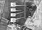
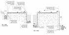
The main problems that exist today are as follows (see the schema of weathering and destructive processes as depicted on a typical section ):
1. Trees and bushes have taken root in the foundation of the pool.
2. Sections of hydraulic plaster are missing and the edges of the plaster are loose.
3. Bushes have taken root in the walls.
4. The curbstone tends to sag.
5. Later repairs have been made to the pavement of the pool.
6. A section is missing in the pavement and foundation; the edges of the pavement are undermined.
7. River pebbles are missing from the pavement.
8. Various types of vegetation have taken root along the top of the wall and in its core.
9. Stones are missing from the top of the wall.
10. Weeds have taken root beneath the plaster.
11. Mollusks and insects are attacking the plaster’s bone-based adhesive.
12. Stones are missing from the channels.
Preliminary Recommendations for Stabilization
The structural state of the Pasha’s Pool is sound. The existence of active weathering and destructive processes are likely to lead to the loss of structural components that will eventually result in damage to its stability. Beyond that, during the course of conducting the survey a number of exposing and cleaning measures were undertaken for the sake of gathering essential data. These measures re-exposed some of the monument’s components to the weathering and destructive processes. The fact that the Pasha’s Pool has been placed on the stakeholders’ agenda presents a golden opportunity, which will probably not reoccur, to promote intervention for the conservation of the monument. At this point in time, before a program is drawn up and the contractors and stakeholders formulate their intentions, it would be highly desirable to implement a number of preliminary stabilization measures to halt the active weathering and destructive processes that are occurring in the pool.
Under proper professional guidance some of the preliminary stabilization measures can be executed with the help of young people and unskilled labor.
Preliminary Actions that are Required at the Site:
These measures call for spraying the vegetation with a herbicide and covering the top of the pool temporarily; selective culling of trees that have taken root in the walls of the pool; steps to prevent mechanical damage in the pool and covering the aqueduct.
Principles for Rehabilitating the Pool and Exhibiting it to the Public:
In discussing the values and cultural significance of the monument three important values were raised that should be considered the object of the planning and future intervention for the site.
Environment: The Pasha’s Pool is an integral part of the Pasha’s Gardens, perhaps even the heart of them, which extend between the upper gardens and the orchards at the bottom of the slope.
Historical Significance: The aqueduct is an integral part of the pool both in a functional and historic sense.
Architecture and Aesthetics: The Pasha’s Pool is unique and unusual from a standpoint of both the quantity and quality of its architectural and landscape values. In keeping with these values one should consider the extent of the different sorts of intervention: in the structure, its presentation and its use.
Alternatives for different levels of intervention were presented in the survey report and they are open for discussion with the survey’s client and the site’s stakeholders.
Acknowledgements
A variety of tools were utilized during the documentation process: surveying, photography, aerial photography, cleaning and washing, exposing and localized excavations. All of these were done in coordination and with the full cooperation of the Manof Youth Village (Yoram, the assistant administrative manager) and with logistical assistance rendered by the ‘Atidot Institute (Shimon, the director general and Adi, the administrative coordinator) to whom we owe our thanks. We also wish to express our gratitude and praise for the contribution by the team of workers on behalf of the World Bahai Center that took care of trimming the vegetation at the site and measurements prior to the beginning of the survey, as well as exposing and cleaning all of the pavement at the top of the pool in order facilitate photographing it from the air.
I would like to thank Eliezer Stern, district archaeologist for the Western Galilee, for first showing me the secrets of this place and the raw potential hidden within it.
A number of professionals participated in carrying out the survey, among them Mark Avrahami, a conservator with the Art Conservation Branch of the Conservation Department of the Israel Antiquities Authority, the engineers Yael Rosenthal and Ofer Cohen (“Ofer Cohen – Building Conservation and Engineering”) and Dr. Avi Sasson of the Ashkelon Academic College.
I sincerely hope that this survey will contribute to advancing the conservation of the Pasha’s Pool, placing the monument on the stakeholders’ agenda, exposing the site to the public-at-large, and in the not too distant future preserve and exhibit it for future generations.
Amir Freundlich – architect
September 2008
To view the figures, click on the figure caption
|