| Nahal Bet Ha-ʽEmeq |
| Nahal Bet Ha-ʽEmeq |
| Survey of Sites along the Stream |
| Orderer | Western Galilee Drainage and River Authority |
| Duration | June-July 2008 |
| Implemented by: |
Arch. Yaara Shaltiel
Landscape Arch. Sivan Ornai
|
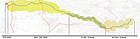
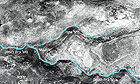
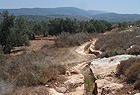
The Nahal Bet Ha-ʽEmeq streambed offers a cultural landscape that incorporates both natural and cultural heritage. The stream is seasonal and dry for most of the year. It drains the western slopes of Mount Haluz and Mount Pelekh north of Karmi’el, and empties into the Mediterranean Sea north of Shave Ziyyon. The middle section of the streambed is a nature reserve (Figure 1).
The survey of the heritage sites along the stream was conducted thanks to the commendable activity of the Drainage Authority, not only with regard to nature and landscape values, but also concerning the cultural, archaeological and historical heritage sites.
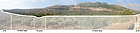
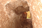
The flora along the stream is Mediterranean and the agriculture consists of traditional mountain farming, particularly olive trees in plots delineated by terraces (Figures 2, 3, 4). Cliffs characterize the landscape in the nature reserve, which is composed of limestone and dolomite rock and where karstic phenomena such as Tefen Cave and ʽEn Yifʽa (ʽAin al-Majnuna, the ‘Crazy Spring’) have developed. The remains of a flour mill are located west of the spring. Further upstream are Horbat Mahoz and Horbat Hesheq, which date to the Byzantine period.
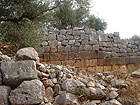
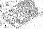
Horbat Hesheq (Qasr al-ʽAshaq). Remains of a Byzantine church. In excavations conducted in 1985, under the direction of Motti Aviam, the church and all of its architectural elements was exposed, including the apse and a mosaic floor in which there are family dedicatory inscriptions. According to Aviam (2002:172) this is best preserved church ever discovered in the north of Israel. The walls of the structure’s upper story are preserved to a height of more than one meter, whereas the wall of the apse has survived to a height of 4.5 m. The method of construction consists of cast stones and cement, which is both characteristic and unique to the Galilee region. The architectural elements of the building that were found in the excavation allow us to reconstruct it completely (Figure 5). The church was apparently used to memorialize a family.
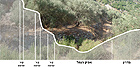
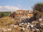
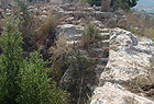
Horbat Mahoz (Khirbat al-Mahoz). Remains of a settlement that dates from the Byzantine period and existed until the Ottoman period are located at this site. The finds include remains of a church, a pool c. 20 meters long, as well as remains of a quarry, farmhouses and farming terraces that are still cultivated (Figures 6, 7).
ʽEn Yifʽa. This spring, located near Yirka, is called ʽAin al-Majnuna in Arabic. The three flour mills that were erected alongside it are indicative of a stronger and more consistent flow of water in the past (Figure 8).
Other Remains: Moshav ʽAmqa – remains of a tunnel and two open, rock-hewn channels were discovered in the moshav (Figures 9, 10). These date from the Roman-Byzantine period to the Ottoman period.
Aqueducts are indicative, among other things, of a significantly greater amount of water than there is today. This complex was most probably used as early as the Persian period.
In conclusion, the Bet Ha-ʽEmeq environment offers material evidence of traditional agriculture and the exploitation of water power used to run mills. The region has not been exposed to the pressures of development; the landscape in the vicinity of the stream is wild and the absence of modern intervention is evident. The olive terraces, some of which are still being used today, are a cultural landscape that displays a combination of natural and cultural heritage.
The remains are scattered the length of the stream and there is not functional connection between them. The settlement remains along the course of the stream further our understanding of the settlement group in the Galilee during the Byzantine period.
The state of preservation of the remains varies from site to site. For example, the church at Horbat Hesheq is well-preserved as opposed to the ancient mills. In one of the mills, for example, only the chimney and part of an aqueduct that serves as a terrace were preserved.
The survey identified three focal points where there is potential for future development: Horbat Hesheq, Horbat Mahoz and the aqueducts leading to ʽAmqa. Development of a trail along the stream will make it possible to present the mill remains. Thanks to the excellent preservation of the rock-hewn aqueducts they can be used as a basis around which various themes can be developed. The aqueducts can be means by which the streambed is connected to the water reservoirs in Moshav ʽAmqa, and paths for walking and bicycle riding can be laid out along them.
Involving the community in the rehabilitation of the stream’s sites, by means of an “Adopt-a-Site” project, in collaboration with the local educational system, can contribute to strengthening the local community’s ties to the place and raising awareness to preserve the remains of the past.
Bibliography
Aviam Mordechai, 2002. Five Church Sites in the Upper Western Galilee. In: Z. Gal [ed.] Eretz Tsafon: Collection of Articles on the Archaeology of the Galilee. Jerusalem, Israel Antiquities Authority. Pp. 165-218 (Hebrew).
Frankel Rafi and Getzov Nimrod, 1997. Map of Akhziv [1], and Map of Hanita [2]. Archaeological Survey of Israel. Jerusalem: Israel Antiquities Authority.
Frankel R., Getzov N. and Friedman D., 1989. The Aqueducts of Acre and the Western Galilee. In D. Amit, Y. Hirschfeld and J. Patrich [eds.]. The Aqueducts of Ancient Palestine: Collected Essays. Jerusalem: Yad Ben Zvi (Hebrew).
Survey of Israel. Cadastre Maps 1950, scale 1:10,000.
Hebrew University of Jerusalem, Department of Geography, Archive of Aerial Photographs.
To view the figures, click on the figure caption
|
|