| Horvat Burgin |
| Documentation as a Basis for Preliminary Planning |
| Orderer | Jewish National Fund |
| Implemented by: |
Landscape Arch. Ido Rosental
Arch. Yaara Shaltiel
|
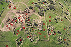
Horvat Burgin is situated in the center of the Judean Shephelah, 10 kilometers south of Bet Shemesh. The site is located in middle of ‘Adulam Park, which is managed by the Jewish National Fund. The remains at the site indicate it was continuously inhabited over the course of 2,500 years, from the Iron Age until the establishment of the State of Israel. Scholars suggest the place be identified with the large Jewish village of Kfar Bish of the Second Temple period, which is mentioned in the War of the Jews by Josephus Flavius. Extensive plundering of antiquities there in recent decades has prompted archaeological surveys and excavations of the site. These excavations have revealed a rich assortment of archaeological finds that have significant tourism potential. In recent years a small portion of the site has been prepared for visitors, where the public can see agricultural installations, burial caves, dwellings and a hiding refuge. The Jewish National Fund is cooperating with the Israel Antiquities Authority for the purpose of planning the site in ‘Adulam Park. In the first stage preliminary planning (a program) was drawn up as a basis for further development and conservation work of the site and its surroundings.
Although the ancient settlement is spread over a relatively small area, the remains associated with it, such as the different agricultural installations, the cisterns and cemeteries are scattered across an extensive area along the spurs and in the wadis nearby. Since 1994 a number of archaeological surveys and excavations have been conducted in this area; nevertheless, many of the remains both above ground and below have not been surveyed and were never mapped.
The first thing we had to do in order to prepare the program was to assemble all of the material that had been gathered so far on the site and its remains. It turns out this is a much more complicated task than we anticipated due to the multitude of surveys, the different methods of mapping and numbering and the manner in which they were carried out. For example, some of the remains were documented before they began using GPS and were only recorded on a schematic map in a manner that even with the assistance of the surveyors themselves it was not possible to locate them again in the field. Sometimes the same remains were surveyed and numbered more than once, but because of the different degree of detail on the part of the surveyors and the level of accuracy of the GPS instruments, duplicate entries were recorded that we had to check out. Through repeated surveys of the site and analyses of aerial photographs from the 1940’s, photographs taken from a balloon and up-to-date aerial photographs we slowly mapped an ‘inventory’ of the most prominent remains existing in the area. The staff of the Jewish National Fund participated in the field surveys and contributed to the planning of another ‘layer’ of the significant natural values in the region.
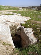
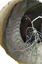
In the analyses and reviews we discovered interesting remains whose existence or content was completely unknown, such as rock-hewn steps that were only discovered by means of a balloon photograph or a hewn cistern that has spiral steps leading down to its bottom, which is a very common type of cistern in the Tel Maresha region but is rare in this area. In another instance we climbed down into a known cistern in the middle of the site and discovered for the first time carvings of various symbols near its bottom. On more than one occasion such exciting finds caused us to modify the planning.
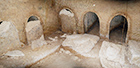
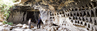
All this notwithstanding, we began the analysis and evaluation phase of the site’s components being fully aware that more is hidden than is known and that only a systematic wide-scale survey with the necessary resources can properly and completely document and catalogue all of the remains. It was clear to us from the outset of our work on the program that it is impossible, and indeed would be undesirable, to present the visitors to the site the dozens and perhaps hundreds of remains that are present there. After a preliminary screening of these remains, we examined their state of preservation, what interest they might hold for the visitor, their engineering stability, the safety risks inherent in them, the amount of development required to display them, their proximity to each other, their accessibility to the existing network of trails etc. In light of these various aspects and considering the existing configuration of trails we finally selected twenty-six remains that are “key sites”, with especially high potential for visitors. These include: the Byzantine church that was exposed in 2011, remains of farmsteads, different styles of burial caves, columbarium caves, underground hiding refuges, ancient roads and rock-hewn steps, cisterns, a well, wine press, and other interesting remains.
The primary objective of the preliminary planning is to formulate a single planning concept for the site and focus the subjects of the visit and the exhibit that will be manifested along the visitor trails. The remains associated with the Second Temple period, most of which are underground, were designated primary subjects in the development of the site. On the hilltop where the settlement’s houses were built throughout history are remains of hiding refuges from the Second Temple period, spread out underground in all directions, and already attracting many tourists to the place. But what is really unique about the Second Temple period at Horvat Burgin is not its hiding refuges, but rather its ancient cemetery, the necropolis (the ‘city of the dead’). The cemetery is outstanding in the amount of burial caves there, their magnificence and opulence, and according to researchers, it is second only to the famous necropolis of ancient Bet Sha‘arim.
Still, a visitor to the site today cannot really discern the numerous caves scattered throughout the area, sometimes just a few meters from the trail. The future visitor’s trail is planned so that the public will experience the variety of the periods and the kinds of burial and will learn about the lifestyle and culture in the settlement throughout history. The key sites from all of the periods will be integrated along the trail, in as logical an order as possible, while at the same time a clearer distinction will be made between the area of the ancient settlement and the rings that surround it comprising the region of the necropolis and the agricultural areas.
The broadest possible collection of archaeological data together with a thorough analysis of the problems at the site constitutes an essential step in formulating plans for every site. The multitude of remains at Horvat Burgin, their distribution across a large area, and the fact that this is an active and partially regulated site were a fascinating challenge for us. The high demands of the Jewish National Fund for a detailed program and allocation of resources for research made it possible to prepare a comprehensive document that faithfully serves the purpose for which it was made.
-------------------------
April 2013
-------------------------
To view the figures, click on the figure caption
|
|