| Hunin |
| Hunin Fortress |
| Preliminary plan for conservation and development |
| Orderer | Jewish National Fund |
| Duration | September 2007 |
| Implemented by: |
Arch. Amir Freundlich
|
As part of the plan to construct a scenic promenade along Ramim Ridge, the Conservation Department of the Israel Antiquities Authority was called upon to draw up a preliminary plan for incorporating the Hunan Fortress in the promenade. This project included a survey of the ancient remains and the drafting of planning alternatives for the purpose of conserving the remains in situ and presenting them in a safe manner and in accordance with the spirit of the place and its value.
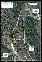
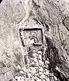
Hunin Fortress is located at the top of Ramim Ridge north of Moshav Margaliot, along the Lebanese-Israeli border. South of the fortress are the remains of the Shi’ite village of Hunin, which are concealed in a grove that was planted by the Jewish National Fund; the village’s cemetery is situated north of the fortress. The eastern access road to the moshav passes east of the fortress and west of it is the precipitous escarpment of Ramim Ridge which descends to the Hula Valley. The fortress covers across an area of approximately 9 dunams and includes a rock-hewn moat, the remains of walls, water cisterns and a vaulted structure that extends across a total area of c. 450 square meters.
Historical Survey
The archaeological research at the site has revealed that a settlement existed there in the Iron Age 1 (1200-1000 BCE) and from the Persian period (586-332 BCE) until the latter part of the Byzantine period (fifth-sixth centuries CE). The artifacts that were found from these periods include fragments of pottery vessels, sections of walls and water cisterns.
It is customary to identify Hunin Fortress with Château Neuf (in French) or Castellum Novum (in Latin), that is to say, the ‘new fortress’, which was erected in the Crusader period along side the postal road that ran from Damascus to Banias and from there onto Tyre and Akko. The fortress was in all likelihood built in the years 1106-1107 CE, together with Toron Fortress (today Tibnin) to its west, as part of the preparations by Hugh of Saint-Omer, the prince of the Galilee, for the campaign against the Muslims who were located in Tyre. Approximately sixty years later, in the summer of 1167, the fortress came under a surprise attack by the Muslim ruler Nur a-Din. The Crusaders abandoned the place and set the fortress ablaze. Nur a-Din’s forces completed the destruction by razing the fortress to the ground.
In 1178 Château Neuf (Hunin) was rebuilt together with the Castle of Chastellet (‘Ataret fortress on the banks of the mountainous Jordan River) by the lord of Toron Fortress, the constable Humphrey, out of fear and anticipation that Saladin would invade the region. Château Neuf fell to Saladin in 1187. The Ayyubid forces occupied the fortress for a period of time but due to strategic considerations they destroyed it in 1218.
In 1266 the Mamluk sultan Baybers conquered Toron and the region around Château Neuf. However by this period the site had lost much of its strategic importance because the road to Damascus had been moved from the mountainous routes south toward Gesher Banot-Ya’aqov-Safad.
During the eighteenth century the site was reinhabited under the rule of Dahar al-Omar. Several fortresses in the vicinity, including Hunin Fortress, were fortified by powerful Shiites, this at a time when the village of Hunin also began to develop around the fortress. Construction activity was carried out at this time within the precincts of the fortress; vaulted rooms were erected in the southern part of the structure and its walls and towers were rehabilitated or completed.
The fortress was apparently abandoned following the mighty earthquake of 1837. The village of Hunin continued to exist until 1948. In 1951 Moshav Margaliot was established there.
Architectural and Technological Description
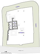
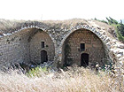
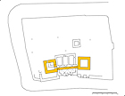
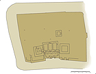
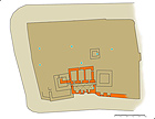
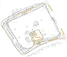
Hunin Fortress extends across an area of approximately 5.5 dunams (c. 60 x 90 m) and is surrounded by a moat (average width c. 12 m) that is hewn in the bedrock. Around the fortress are the remains of a wall and fortifications that predate it. Four halls were built in the southern part of the fortress on the remains of fortifications that date to the beginning of the twelfth century and the remains of a vaulted building from the eighteenth century.
The Gate Structure (I).
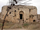
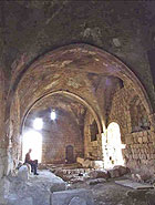
This is a rectangular hall that was built on the edge of the southern moat, and it is composed of three groined vaults covering a total area of about 200 square meters. In the building one can discern the secondary use of ancient masonry stones and what may also be the remains of earlier fortifications. The structure is extremely well preserved except for missing voussoirs in the arch and doorjambs that were robbed from the openings. In the eastern part of the hall is a blocked opening of a water cistern.
Three halls with barrel vaults oriented in a north south direction were built perpendicular to the gate structure:
The Eastern Hall (II). In this hall there is a visible seam that runs the width of the vault which is indicative of several phases of construction. This hall is extremely well preserved. It is complete for its entire length, except for the masonry stones that are missing at the top of the northern curtain wall and the core of the hall’s outer northeastern corner which is exposed and undermined. In 1994 this chamber underwent conservation treatment that included the completion of missing stonework and the pointing up of the joints.
The Central Hall (III). Most of the barrel vault was destroyed to its base. There is an opening in its northern side that leads an earlier complex of water cisterns.
The Western Hall (IV). This hall was also destroyed to its foundations; its floor is covered with collapse and alluvium.
On either side of the vaulted building and beneath it are the foundation courses of a fortification from an earlier phase of the fortress. The remains include a pair of massive towers and a wall that connects them, all of which are in a very poor state of preservation. Northeast of the vaulted building were discerned the remains of a small square structure in which there is an opening to a water cistern. Besides these there are numerous water cisterns (at least eight) scattered in the area of the fortress, some of which are filled with water year round; however, none of the cisterns were surveyed systematically. The water cisterns were used by the residents of Hunin village until the middle of the twentieth century.
The fortress is surrounded by a deep, rock-hewn moat that probably dates to the later phase of the fortress. Today there are only c. 3,800 square meters of moat that are visible because the approach road to Moshav Margaliot was built on the eastern side of the moat and its southern side is probably partly blocked. Evidence of an earlier presence such as rock-cuttings, caves and water cisterns were documented along the moat. Today the inside of the moat is a natural habitat for a rich variety of flora such as fig, oak and pistachio trees.
Conservation Intervention
Some of the fortress’s vaults collapsed in the winter of 1994. As a result of this a team from the Conservation Department of the Israel Antiquities Authority under the direction of the late Yossi Broida carried out conservation work there. At the same time archaeological excavations, on behalf of the Antiquities Authority and directed by Iden Shaked, were conducted around and inside the vaulted halls.
Principal Recommendations
Within the framework of the preliminary planning proposal, two phases of rehabilitation are recommended: In the first phase a visitor’s path will be prepared that will pass through the moat around the fortress; this will be a continuation of the planned promenade. Due to safety considerations the path will pass as far as possible from the remains of the inner wall and at the same time the remains of the fortress will be treated in order to ensure the safe passage of the visitors there. Extending the promenade into the moat will allow visitors to get a sense of the work that was involved in quarrying the moat, as well as see the remains that predate the fortress (the water cisterns), the geological formations (along the northern bend) and the rich flora (oak, fig and pistachio).
In the second phase the interior spaces of the Shiite fortress (that date from the eighteenth century until the earthquake that struck in 1837) will be rehabilitated for visits by the public. This future project can be implemented in three stages, in keeping with the contractor’s budget and in accordance with the future interface of the site. In the first stage the gate structure will be rehabilitated; in the second stage the barrel vault of the eastern hall will be rehabilitated and in the last stage work will be done to stabilize and prepare the center and western vaults (III and IV) and their levels. The first two halls (I and II) are in an excellent state of preservation; however, the two others (III and IV) have mostly collapsed. It is therefore suggested that the two former halls be rehabilitated as covered spaces whereas the two latter ones be treated at their current state of preservation without any extensive additional reconstruction.
At the time the aforementioned conservation plan was being drafted Dina Avshalom-Gorni, an archaeologist with the Eastern Galilee and Golan District informed the Architecture Department of the Tel-Hai Academic College of the work the Conservation Department of the Antiquities Authority proposed doing. The college adopted the site as its main project for the 2007-8 academic year for all of the different professional trends that the department offers. And for that we offer our blessing and hope that in the coming years there will be more activity of this kind in the field of cultural heritage.
To view the figures, click on the figure caption
|
|