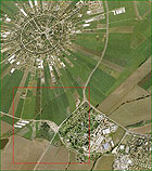
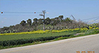
Tel Sefan, in the Jezreel Valley, is a gentle hill located west of Kibbutz Ramat David and south of Moshav Nahalal (Figs. 1, 2). The ʽEn Sefan spring flows to its south. The tell rises c. 10 m above its surroundings and affords a comfortable view of the region. Owing to its location in the heart of a fertile agricultural valley the place became a center for settlement at the dawn of human history. Trees are planted on top of the tell and along its slopes; at the foot of it are the remains of orchards and wet habitat undergrowth.
The aim of the project was to propose a conceptual plan for the conservation and development of the mound. The plan will deal with the settlement of the Jezreel Valley over the course of the different periods. The site is of local importance and thus has the potential of serving the regional educational system and the residents of the area.
The plan proposes a visitors trail along which the story of the settlement in the valley throughout history will be presented.
Historical-Archaeological Description
Paleolithic Period (600,000 – 12,000 BCE). Flint implements were found at the foot of Tel Sefan.
Neolithic Period (9,500 – 6,400 BCE) and Chalcolithic Period (6,400 – 3,600 BCE). Agricultural settlements were located in the region which later developed into urban settlements (in the Bronze Age 3,600 – 1,200 BCE).
The spatial distribution followed the model of a central city with small settlements around it. For example, a major city was apparently situated at Tel Shimron, located near Nahalal Junction. A number of small settlements were established alongside the city and close to the sources of water. These are the small mounds in the valley such as: Tel Sefan, Tel Shem, Tel Reʽala and Tel Shor.
The finds from these ancient periods are evidence of the beginning of habitation in the area and the development of agriculture in the valley.
Iron Age (1,200 – 586 BCE). The Jezreel Valley was important at the beginning of the biblical period when four of the tribes of Israel settled in the region: Issachar, Zebulon, Asher and Naphtali.
Architectural remains dating to the Iron Age were discovered in an initial excavation conducted by Avner Raban at Tel Sefan in 1982.
Persian Period (586 – 332 BCE). The finds at Tel Sefan point toward the existence of a rural settlement there.
Hellenistic Period (332 –37 BCE). During this period the rulers of the Hasmonean dynasty received land in the valley which was used for farming.
Roman Period (37 BCE – 324 CE). The Sanhedrin moved to the Galilee following the destruction of the Second Temple and the settlement in the valley flourished. The importance of the region began to decline toward the end of the period.
Remains of a Roman road were discovered next to Tel Sefan. This road apparently connected the region with the government center at Legio (near Megiddo) and Caesarea.
Byzantine Period (324 – 638 CE).The settlement sequence at the tell was also maintained during this period.
Remains of a farm were found on the tell.
In the Middle Ages the size of the settlement in the region was reduced. This trend continued in the Early Islamics periods (628 – 1099 CE ) and in the Ottoman period (1516 – 1917 CE). The remains of a small rural settlement from the Mamluk period (1250 – 1560 CE) were found on the tell; however, it was probably built prior to this during the Crusader period (1099 – 1187 CE).
In the Late Ottoman period Bedouin tribes took control of the valley and several meager permanent settlements were established there. The land on and around Tel Sefan was the property of the Sursuq family of Syria and was worked by tenant farmers.
Time of the British Mandate. In the 1920s and 1930s the land around the tell was purchased from the Sursuq family in order to establish another settlement next to Moshav Nahalal (1921). However, disputes with the tenant farmers delayed the founding of the settlement for ten years. From the 1920s various groups of settlers (so called kevutsot) occupied the area around the tell (among them Kevutsat Ha-Roʽim, Kevutsat Ha-Tsafon, Kevutsat Ha-Sharon etc). The groups stayed there for short periods and went on to found new settlements elsewhere in the country. In 1931 Ramat David was built east of the tell.
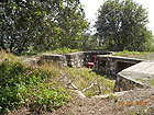
During the Second World War a concrete outpost was dug into the top of the tell as part of the defenses around the airport (Fig. 3).
Initial Plan
The plan proposes presenting four main themes along the visitor’s path at the site:
· The kinds of settlement in the valley throughout history
· Growing wheat in the valley
· Traditional handicrafts in everyday life
· Draining the swamps in the valley
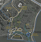
The main points of the proposed plan (Fig. 4):
1. A training center and exhibition dealing with wheat in the visitor’s center.
2. An observation point located at the top of the tell, and rural settlement models in the anti-aircraft position.
3. Placing models of the rural house at the foot of the tell.
4. Traditional harvesting in a specially designated place and threshing on a threshing floor, in season.
5. A permanent exhibition and building with mudbricks next to the planned water course.
6. A workshop compound dealing with “daily life in antiquity”.
7. An exhibition on the “Draining and Preparing the Land in the Valley” in the old pump house.
8. Returning via the thicket path to the visitor’s center/parking.
The proposed starting point is the visitor’s center at the foot of the tell. From there the visitor will climb to the top of the tell where the story of the settlement in the valley will be presented by means of models of the three important settlement periods in the region: the Iron Age, Ottoman period and Zionist settlement.
Further along the path visitors will encounter life-size or miniature models of buildings from the three periods where they can learn about the technologies involved in constructing them.
In addition, a section of the path will focus on wheat which characterized the agriculture in the valley throughout history. On the slopes of the tell the visitor can try his hand at threshing, milling and baking using ancient technology. Nearby the visitor will also be able to experience other daily chores characteristic of the Iron Age such as mud brick construction, spinning, weaving, weaving mats and making pottery on a potter’s wheel. The story of how the swamps were drained in the valley will be presented in the old pump house which was built near the spring in an area that was drained in the early twentieth century.