| Usha |
| Horbat Usha |
| Plan for the Conservation and Development of the Site |
| Orderer | Zvulun Regional Council |
| Duration | August-December 2008 |
| Implemented by: |
Arch. Yaara Shaltiel
|
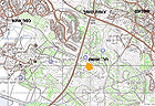
Horbat Usha is today located in the Usha National Park and covers an area of 263 dunams (the antiquities site was declared in 2009). It extends across the slopes of the Qiryat Ata forest, north of Nahal Zippori, east of Highway 70 and south of Somekh Junction. The site is reached by way of the Qiryat Ata – Zippori scenic route (Fig. 1).
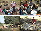
The aim of the work was to identify the cultural values of Talmudic Usha and propose a plan for the conservation and development of the site. This, prior to implementing the “Adopt a Site” project that has been operating since 2007 in the Nizanei Zevulon Regional School. The project is being led by two of the school’s teachers Mr. Davidi Shavit and Ms. Hagit Goldman (Fig. 2).
Evidence of two main periods was found at Horbat Usha. The early period, Talmudic Usha where the Sanhedrin used to convene and the late period, Hosha village of the nineteenth century.
Talmudic Usha
Following the failure of the Bar Kokhba Revolt and the transfer of the Jewish settlement to the Galilee, the Sanhedrin moved from Yavne to Usha where it was located for ten years from 140 CE.
Rabban Shimon Ben Gamliel II, the rabbi of Usha and a disciple of Rabbi Akiva, headed a council that was popular in nature. The sages of Usha enacted religious rulings (takkanot) that mainly dealt with social and family issues. These rulings were named after the place and are called “the Usha Enactments”.
Among the torah sages that resided in Usha were: Rabbi Shimon Bar Yohai and his son Elazar, Rabbi Meir, Rabbi Yehuda Bar Ilai and Rabbi Yehuda Ha-Nasi, Rabban Shimon Ben Gamliel II and Rabbi Yehuda Ben Baba.
The antiquities at the site include remains of wine presses, a ritual bath (miqwe) and an olive press. There are also ancient terebinth trees there that are hundreds of years old. It is thought remains of a synagogue from this period are located there which has not yet been confirmed.
Hosha Village
At the end of the nineteenth century the Ottoman government settled Muslim immigrants from the Maghreb there. The houses of the later village were built of stones taken from the ancient settlement (Fig. 3). The village at that time stretched across an area of c. 1,000 dunams and its population numbered 300 inhabitants.
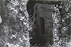
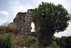
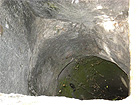
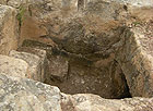
The inhabitants fled the village following its conquest in 1948 (Fig. 4). In an action initiated by the army in the 1960s the houses in the village were demolished but they were not destroyed to the level of their foundations. Remains of the buildings stand along an alley. Most of the walls were preserved to a height of one meter and one of the buildings has survived to a height of three meters (Fig. 5). Inside one of the buildings is an opening of a cistern (Fig. 6).
Archaeological Research
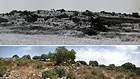
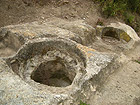
Usha was surveyed in the 1960s at which time the following antiquities were documented: wine presses, a cemetery, a sheikh’s tomb, the ruinous houses of the village, an olive press (Fig. 7), ritual bath (Fig. 8) and a wide variety of flora and trees hundreds of years old. To date, there has been no in-depth study of the remains of the ancient settlement; however many rock-hewn installations located at the site date to the Talmudic period.
The complex of rock-hewn wine presses includes treading floors on which the plaster is preserved, screw-press bases, drainage channels for the must and rock-cut collecting vats that are reached by way of hewn steps (Fig. 9). A fermentation vat with a mosaic pavement is located just west of the wine presses. The wine presses indicate the existence of vineyards nearby and that wine was produced there.
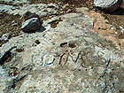
In the Qiryat Ata forest, between Usha and Shefarʽam, is a rock that bears the inscription "תחום שבת” (meaning the Sabbath boundary). This probably denotes the Sabbath boundary of ancient Usha (Fig. 10).
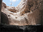
Every year from 2005 until the present a study excavation has been conducted at Horbat Usha, which was undertaken on behalf of the Israel Antiquities Authority and underwritten by the Zevulon Regional Council. The study excavation is directed by A. Oshri and is being carried out with assistance from sixth grade pupils at the Nitzanei Zevulon Elementary School and volunteers from the surrounding area (Oshri 2012).
Evaluation of the Cultural Significance
Historical Value: Usha was the seat of the Sanhedrin.
Religious Social Value: The religious canon took shape in Usha, and it is where the Mishnah was written and broad leadership of torah sages was established.
Landscape Values: The settlement remains are integrated in the ancient flora and local vegetation (almond, carob, fig, sage etc) that were used by the residents for food and herbal remedies.
Scientific Values: The physical remains of Talmudic Usha have not yet been excavated and studied, so there is potential for archaeological research that might shed light on the daily life there during this period.
The Principles of the Proposed Plan
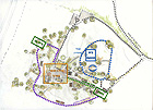
The plan proposes developing a number of routes through the site (Fig. 11).
1. The Sanhedrin route. This path will pass through the remains of the ancient synagogue and six stations where important figures that were active in Usha will be presented. At each station a tanna (rabbinic authority at the time of the Mishnah) and a local ancient tree will be presented. This combination will symbolize the idea of the long existence of the heritage of Usha, both from the standpoint of culture and that of nature.
The planners propose that the pupils build a bench decorated with a mosaic work at each station. The source of inspiration for the design of the path will be a depiction of the discussions the rabbis held in a semi-circle. The route will end in an open area that will allow the group of visitors to pause awhile and hold a discussion as was done in the days of the Sanhedrin.
2. The Crafts Route. This path will lead to the complex of wine presses situated in the east of the settlement. It will pass between the architectural remains where workshops of traditional crafts will be held such as pottery making, minting coins and basket weaving. The workshops will emphasize the use of local vegetation and visitors will be invited to try their hand at a variety of handicrafts. The route will end at the rock-hewn wine presses that were located at the fringes of the settlement. It is proposed the wine presses be restored. The workshops should be designed in a regular style similar to the fabric of the village houses. It is proposed that the workshops be covered with roofs made of mats that will be woven using traditional techniques.
3. The Grove and Orchard Route. This path will run from the wine presses to the slope along the edge of the settlement and end at the olive press. It is proposed that signage be posted along the path which will describe the local vegetation and provide information about the different uses that were made of it throughout history. In addition, it is proposed that the remains of the orchard be rehabilitated and even augmented with plantings and that grapevines be planted near the wine presses.
From this route one can continue to the tomb of Sheikh Nebi Hoshan or Nahal Zippori.
As of September 2012 the Zevulon Regional Council, together with the Israel Antiquities Authority, is promoting the implementation of the preliminary stages of the plan. These stages, which cost 600,000 NIS, will be underwritten by the “Heritage Program” in the Prime Minister’s Office and the regional council.
Sources:
Oshri, Aviram 2012. Horbat Usha, Preliminary Report. Hadashot Arkheologiyot-Excavations and Surveys in Israel, Volume 124 ( HA-ESI 124).
Shavit, Yaʽakov (Series editor) 1982. The History of the Land of Israel: The Period of the Mishnah and Talmud and Byzantine Rule. Edited by Moshe David Har. Jerusalem (Hebrew).
Olami, Yaʽakov and Gal, Zvi 2003. Map of Shefarʽam, Archaeological Survey of Israel. Jerusalem.
To view the figures, click on the figure caption
|