February 2013. At the end of another session, one of many over the past two years, the chairman of the Jerusalem district committee announces the planning board’s decision to nullify the detailed plan for the construction of a neighborhood comprising some 1,300 housing units in the southern part of Ramat Bet Shemesh in order to preserve the Horbat Qeiyafa archaeological site in its landscape context and to develop it as a national park.
With this important and quite possibly unprecedented step a planning policy was set forth that considers heritage preservation and the development of an archaeological site in its landscape context to be a value on a par with the urgent need for the construction of housing units and the development of new neighborhoods.
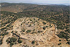
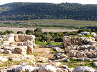
Horbat Qeiyafa, located at the top of one of the hills that encloses the Valley of Elah from the north, between Sokho and ʽAzeqa, is of very great archaeological and historical importance and stands out prominently in the landscape. An important city was situated there at the time of the Kingdom of Judah. Archaeologists Yosef Garfinkel and Sa’ar Ganor have been excavating the site since 2007, and its excellent state of preservation is quite exceptional. The oldest Hebrew inscription was discovered at the site, as well as other unique finds that mostly date to the Iron Age 2, including a casemate wall, two gates, dwelling units and an item the excavators believe to be a stone model of the temple. There are those that suggest it be identified with the biblical city “Shaʽarim” mentioned in the list of cities of the Kingdom of Judah, and again following David’s victory over Goliath, when the Philistines retreated by way of Shaʽarim toward Gath and Ekron (I Samuel 17: 52).
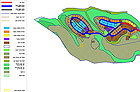
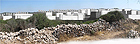
The city of Ramat Bet Shemesh is rapidly being constructed on the hills north and east of Horbat Qeiyafa, in accordance with building plans that were approved in the mid 1990s. On the basis of the plan the site was meant to remain an open enclave, surrounded by construction on three sides. The detailed plans were designed by dozens of planners, experts and consultants led by the Ministry of Construction and Housing. The planning process was accompanied by archaeological surveys that were performed in the 1990s (Survey of Ramat Bet Shemesh by Yehuda Dagan in 1995 and a detailed survey by Alla Nagorsky, 2011). Hundreds of antiquity sites of various sizes and scope were marked in the area slated for construction. The planning approach presented by the Israel Antiquities Authority concerning smaller sites was to approve the building plans provided any decision regarding the sites’ ultimate disposition would be taken after their excavation, in accordance with the finds, not long before the area’s development. Unlike them, the large important sites such as Yarmut and Beit Natif were to remain as enclaves within the built-up area nearby. The planning process of the city did not formulate a policy for these sites and for dealing with their new situation, and no solutions were outlined that addressed their preservation, presentation, accessibility and appearance in the urban landscape.
A different approach was devised for Horbat Qeiyafa. Due to its location along the fringes of the built-up area, in a region that overlooks the Valley of Elah, and given its potential as a national tourism and heritage site, the conservation appendix sets forth the following:
· The site is unique in that it clearly illustrates the relationship between the “narrative” and the finds in the field. The combination of its values with its landscape characteristics, and it being an excavated site where one can experience rare finds that are exceptionally well-preserved leads us to the conclude that Horbat Qeiyafa has the development potential as a site that will draw visitors from all parts of the country.
· The site was extensively excavated and can be opened to the public immediately.
· The potential for understanding, preserving and developing the site depends upon maintaining it within the open landscape context. It is necessary to distance the built-up area from the site, thereby preserving the open landscape environment, including the wadis around it, and creating a substantial buffer zone between the site and the city to the north.
· The building plan for the neighborhood adjacent to the site (Neighborhood D-6), including its infrastructures and roads, will not make it possible to maintain these principles; hence the plan should be nullified.
This position, which against all odds managed to “turn the tables” and called for the nullification of the plan allowing construction adjacent to the site, won the backing of the IAA administration and was consistently presented throughout the long complex process that was fraught with pressures and objections. It was recently shown that the professionalism and consistency paid off. The position of the IAA was also adopted by the Nature and Parks Authority and it was ultimately accepted by the planning commissions. Nevertheless, it is our duty to remain vigilant until Horbat Qeiyafa will be legally declared a national park which will pave the road for its conservation and development in a manner befitting such an important site.