| Bet Arieh |
| Bet Arieh |
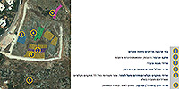
| A Preliminary Plan for the Site and Its Surroundings |
| Duration | September 2013 |
| Implemented by: |
Arch. Avi Mashiah
Arch. Yehonatan Tzahor
|
Bet Arieh is a community settlement founded in 1981. It is named after Arieh Ben Eliezer ז"ל, a commander of the Irgun, and one of the leaders of the Herut political party. The settlement is situated at the eastern end of a rocky spur, c. 400 m asl, on the southern bank of Nahal Shiloh, c. 4 km east of Rentis Junction and c. 9 km south of Rosh Ha-'Ayin. The settlement looks out over Wadi Al-Hakim and Wadi Zarqa and the meanders in Nahal Shiloh situated to its north.
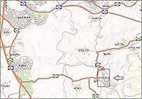
The archaeological site – an agricultural settlement dating to the Iron Age II – is located mainly on the eastern slope of a spur that descends north toward Nahal Shiloh (Fig. 1).
The aim of the project was to prepare a preliminary conceptual plan for the conservation and development of the site. The project included a survey of the finds, identification of the place's characteristics and values and a planning proposal.
The site was first identified by David Eitam in a survey he conducted of the Map of Badiyah in 1976. The site was classified in the survey as an industrial village where oil was produced. Salvage excavations were begun at the site in 1991, in the wake of construction activity. The excavations were directed by Shimon Riklin and they concluded in 1994. Impressive remains of an agricultural settlement dating to the Iron Age II (1000–586 BCE) and extending over an area of c. 5 dunams were revealed in these excavations. Other archaeological sites are located in the vicinity of the ancient settlement, among them: Banat Bar/Zereda, Deir Qala'a, remains of Roman-Byzantine farmsteads, Aboud village and mountain agriculture.
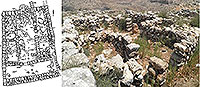
During the course of the excavations remains of a settlement were exposed that was surrounded by a casemate wall, which is a type of fortification that adjoined the outer wall of the dwellings. The rear room of the dwellings formed a casemate for the city wall. A strip of buildings constructed on the slope faces northeast.These structures are characterized by four-room houses. Although they are in a poor state of preservation, the urban fabric, open areas, the plazas connected by streets, staircases and terraced areas can still be easily identified (Fig. 2). South of the dwellings are the remains of eleven agricultural installations.
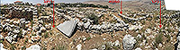
A structure built of roughly hewn stones was preserved in the southern part of the site. The walls of the building have survived to a height of approximately 2 meters. Hewn cupmarks are in the center of its courtyard and a small oil press and crushing stone are in its southern part. Soot and lumps of charcoal were found on the floor indicating it was probably destroyed by a fire. The nature of the construction there reflects both the village’s economic strength and the power of the nation (Fig. 3).
The settlement was dated on the basis of the ceramic artifacts to the late Iron Age II (1000–586 BCE) and it ceased to exist at the end of the eighth century BCE.
In 2012 the Archaeological Staff Officer of Judea and Samaria carried out stabilizing measures and maintenance at the site.
The Cultural Significance of the Site
The site is evidence of life in the settlement during the Biblical period. It is an important source of information from which we can learn about the culture, society and community at that time. There is a variety of physical evidence at the site that reflects the rural nature of the settlement: four-room houses, oil presses, wine presses, agricultural installations, agricultural crops and field towers.
The location of the settlement above Nahal Shiloh, which includes a vantage point that looks out over the stream and the Tel Aviv metropolitan area to the west, reveals the biblical landscape of Khirbet Banat Bar, which has been identified as biblical Zeredah. This is a site that has not been damaged by recent development despite its proximity to a modern settlement. It serves as a bridge between the developed area and its natural surroundings as evidenced by the groups of rock hyraxes that live in the nearby caves around the site.
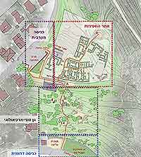
The site is an example of an ancient settlement whose development was planned according to its functions: residential, public institutions and industrial. The remains in it include modular residential buildings arranged in a row, a street, an alley, a square, and open spaces. This is evident in the casemate wall that is incorporated in the walls of the dwellings. The casemate wall not only provided protection, but storage spaces were also integrated in it (Fig. 4).
The region where the public buildings are located has still not been excavated; however, the potential for future research exists there.
The Conservation and Development Planning
The purpose of the planning is to create a connection between the residents of the place and the site, and between the visitors and the historic and landscape values of the site. This can be accomplished by developing an archaeological-landscape park and conserving and presenting the ancient remains in a manner that encourages leisure activities and allows educational activities at the site.
The Planning Principles
1. Variety: create a diversified archaeological-landscape park composed of archaeological finds, hiking trails, an observation point, an educational area and visitor center.
2. Connection to the Settlement: by means of two entrances: a southern entrance (from Lavona Street) where there will be parking, an observation point and playground, and from the west (Koranit Street) where there will be parking for automobiles and buses and an entrance to the site, the visitor center and the planned educational area.
3. Visitor Center: will be placed at the interface between the site and the settlement so as not to disturb the original landscape context which has survived. It will be built of modern materials in order to distinguish it from the archaeological finds. The structure will have a clean and simple design so as not to stand out in the landscape and the finds.
4. Visitor's Route: the planned route will connect the two entrances to the site. It will lead visitors through the region of agricultural installations and in the area where the dwellings were excavated. There will be places where explanations can be given, as well as for observation and rest.
5. Education and Training: the western part of the site, which has yet to be excavated, where here is a region with public buildings, will be the focal point for community activity, education and training. This will be a shaded area where groups can stay (Fig. 5). Young people will also participate in the conservation and development activities.
The Current Plan can be Implemented in Stages
1. Preparation of hiking paths so the site will be accessible to the public. Signage will be posted in this stage and activity with the nearby school will be promoted in order to involve the young people in the conservation and development work.
2. Development of trails and places to assemble and rest, etc. Benches and lighting will be installed.
3. Preparation of parking and an upper observation point, the installation of shading, and landscape development.
4. Depending on the existing resources – an archaeological excavation in the region where there are public buildings and the construction of a visitor center.
To view the figures, click on the figure caption
|
|