| Zanukla |
| Horbat Zanukla |
| Preliminary Site Planning |
| Orderer | Shoshani family |
| Address | Gush 29708, Lot 25 |
| Implemented by: |
Arch. Avi Mashiah
Arch. Yehonatan Tzahor
|
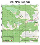
Horbat Zanukla is a declared antiquities site, located at Givʽat Mashav in the Mateh Yehuda Regional Council. The hill rises to an elevation of 662 m above sea level from which there is a view looking out over the landscape toward the Shephelah and the coastal plain. The Jerusalem Breakthrough Memorial honoring those that opened the road to the capital was constructed on its southern slope. Highway 1 (the Jerusalem–Tel Aviv road) and the Shoresh Interchange are located south of the hill. Yitzhak Rabin Park is located north of the hill. A small Arab village called Khirbet ez-Zanuqla was situated on this hill until the War of Independence (1948). The remains of one structure are all that has survived of the village's buildings. The Jerusalem – Tel Aviv highway runs south of the site and north of it is Diefenbaker Road, which the Jewish National Fund constructed in Yitzhak Rabin Park.
The property owners asked that the main historic building that survived at the top of the hill be conserved and developed. The proposed plan was drawn up by the Conservation Administration of the Israel Antiquities Authority. Our plan calls for highlighting the values of the historic structure and its construction technology. This will be accomplished by physically reinforcing the remains, conserving them and removing modern additions that distract from its authenticity. Ing. Jacob Sheffer performed a conservation-engineering survey of the building.
The Urban Environmental Context
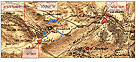
Givʽat Mashav is surrounded by three settlements that were founded close to the time of the War of Independence: Sho'eva, Shoresh and Neve Ilan. Moshav Sho'eva is named after "The Upper Pump House" which was constructed in 1936 as a fortified building that was part of the system providing water to Jerusalem. Moshav Neve Ilan, which was conquered and settled several times, rises on a hill northwest of Givʽat Mashav. Moshav Shoresh was founded in 1948 by immigrants from Eastern Europe and Ha-Oved Ha-Tzioni movement. Memorials and military heritage sites are scattered about the region. East of Givʽat Mashav is the Jerusalem Breakthrough recreation area honoring the Sixth Regiment of the Palmach. The “Armored Convey from 1948” can be seen to the west, “Command Post 1” is located on Givʽat Mashav, and not far from it is “Command Post 2”, in Neve Ilan. South of the Shoresh Junction are remains of the Arab village of Saris, which was conquered and destroyed in April 1948.
Historical and Archaeological Description
Victor Guérin passed through the village of Saris in 1863. He called the hill Mount Seir, which he identified as part of the boundary of the tribe of Judah: "And the border turned about from Baalah westward unto Mount Seir, and passed along unto the side of Mount Jearim on the north – the same as Chesalon…(Joshua 15:10).
In 1874 the French archaeologist Charles Clermont-Ganneau reported finding an ancient stone column in a cave next to a place called "Zanuqla" which appears on Van de Velda's map (1858) as “Horbat Saris”.
The site appears on the map of the Palestine Exploration Fund of 1880 where it is designated a ruin by the name of Zanuqla, situated north of Saris. Hence the name of the ruin Zanuqla was already known in the nineteenth century.
Historical photographs show that the hill was uninhabited up until 1917; hence, the Arab village or farmhouses could only have been built there after that year. The village existed until the 1948 war. Today the site is located in a 120 dunam plot that is zoned for agricultural and scenic uses. This designation is meant to preserve it as an open area and landscape attraction.
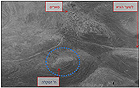
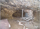
In December 2006 Alla Nagorski performed a preliminary archaeological survey on Givʽat Mashav. In this survey fifteen points were documented where remains of ancient buildings and walls protruding from the ground were found. In addition, a rock-hewn cave was also discovered whose opening is adorned with a stone arch. Four plastered water cisterns were also located.
Environmental Values. The site is located on a hill with a strategic and topographic advantage that controls the road to Jerusalem. It is situated in a natural environment, in an undeveloped area located in the middle of a region where there are nationwide infrastructures, roads and settlements. There is a spectacular view from the hill looking out to the west, to the Shephelah and the greater Tel Aviv region as far as the sea.
Historical and Cultural Values. The site and its surroundings are evidence of an ancient agricultural landscape that includes terraces, cisterns and indigenous flora.
Nearby Giv‘at Neve Ilan and the pumping station constitute an important historical complex in the battle heritage of the War of Independence and the road up to Jerusalem. The monument to the Jerusalem breakthrough and “Command Post 1”, located at the site, are a key component in preserving this heritage and its commemoration
The site, with all its remains, tells the history of the place, before the establishment of Israel and afterwards, including the social and settlement changes it underwent.
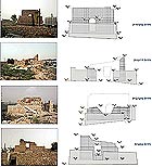
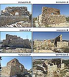
Historic Building on the Hill. The building was constructed on a natural bedrock terrace above the natural cave that was enlarged utilizing technologies characteristic of the early decades of the twentieth century. The wall stumps are characterized by irregular construction, with large stone wedges and remains of cement-based plaster on them. The eastern wall is preserved to its full height. Niches are partially preserved in the wall and plaster remains have survived on it. Remains of a ceiling and a stone pavement are in the northeastern corner of the building. The northern wall was partially preserved. An arched window was fixed in that wall and there are remains of a niche and interior plaster.
In the northeastern corner of the building are remains of a flat debesh-built ceiling that was supported on steel rails or beams aligned in a north–south direction. The original width of the ceiling that abutted the eastern wall, the plaster between the ceiling and walls and from the top of the eastern wall (coping) that protrudes slightly above the ceiling are still very impressive. The remains of cement-based plaster on the western wall and terrazzo tiles on the window sill are among the modern intervention apparent in the building. A concrete wall lined with stone surrounds and supports the building.
A modern arch and wall are visible in the entrance to the cave. The cave consists of two halls: a short eastern chamber and a long western chamber. A concrete pillar meant to reinforce the wall of the historic building passes through a circular opening in the ceiling of the cave.
The Conservation and Development Plan Proposed for the Site
The purpose of the plan is to outline the conservation principles of the archaeological and historical remains and the development principles of the historic building on the hilltop as a space intended to be used for education and to illustrate the place.
The intervention principles formulated in the proposed plan:
• Conservation of the building in its historic environment: rehabilitation and development of the ancient agricultural landscape – farming terraces, orchards and water cisterns around the building.
• Preservation of the historic building: stabilizing and conserving the wall stumps by removing vegetation, sealing the tops of the walls, filling joints, filling the core of the walls and completing them with lime-based mortar.
• Emphasize the stone construction technology: highlighting the manner of building the stone walls, doorways, niches and the arches in the historic building.
• Remove the modern wall around the historic building in accordance with the conservation engineer's recommendation. This wall causes damage to the structure and accelerates its physical deterioration.
• Cover the historic building: utilize materials and modern construction in a manner that does not overload the structure and damage it.
• Separate the old from the new: utilize modern materials that are distinguishable from the material and the mass of the historic building, in order to highlight the history against the background of the new additions and vice versa.
List of References
Guérin V. 1982. A Geographic, Historical and Archaeological Description of the Land of Israel. Volume 1: Judah (1) (transl. from the French by H. Ben-Amram). Published by: Yad Ben Zvi, Jerusalem, 1982. Jerusalem (Hebrew).
Y. Ziv. 2001 The Command Posts Spur. From http://www.yad-leyuval.org.il/more2001.htm. (Hebrew).
PEF Map 1880: PEF1880-017sheet_XVII.jpg
Clermont - Ganneau C. 1874. Archaeological Researches in Palestine during the Years 1873-1874. Vol II. Translated by J. Macfarlane Palestine Exploration Fund, London 1896.
To view the figures, click on the figure caption
|
|